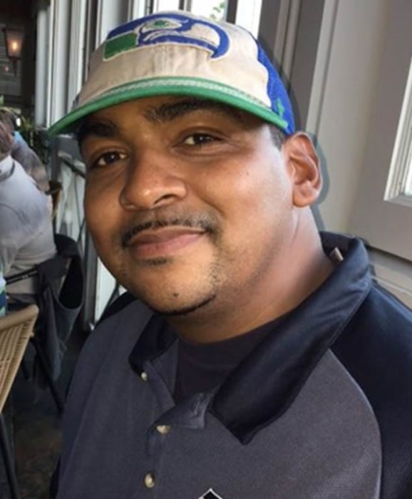
CA CA - Rico Harris, 37, Former Harlem Globetrotter, Yolo County, 10 Oct 2014

Some addenda to above:

I have now watched the documentary on Rico's disappearance. The interviewer found a junkie in Clearlake who swore his buddy drove to Cache Creek to sell crank to Rico. Of course, this makes no sense. How the friend knew Rico was there went unquestioned, as did the necessity for Rico to drive over and fetch him. This is apparently the bogus story that started the Clearlake crank tale. If Rico picked up crank in northern California, it seems to me that Sacramento is a much more likely source. It is an urban drug market, customary to Rico's experiences.

Respectfully... if there's any place in Northern California where you can score any drug...it's Lake County, which includes Clearlake. Not saying this story isn't made up, just my insight being from a neighboring county.
 
No insult taken. Having spent a recent decade in Lake County, I am not about to argue about availability of drugs in the City of Clearlake--or of meth labs either. But that was not the point I was trying to make. I was trying to point out the unlikelihood that an addict from an urban environment would somehow find a dealer in a small hick town miles and miles off his route. And if the dealer came to Rico instead of the other way around, how did Rico call the dealer from a dead call zone? Did Rico locate this Clearlake dealer over the Internet? There are two competing scenarios offered, contradictory of one another, one grossly improbable and the other impossible.

On the other hand, a dip off I-5 into Sacramento would land him in the familiar urban stew. However, most likely of all, as we humans are such slaves to habit--he probably scored from his usual contact down in Alhambra before he started north. Evidence for all this cerebration being a single empty bindle found in his abandoned car.
 
For those having difficulty researching the geography of this event: The middle lot of the three has the restrooms, etc. That's where Rico stopped. The actual lower (southern) site is used seasonally by white water rafting expeditions.
 
As I have dug into this case further, Ihave discovered that Rico's use of the southern end of Hwy 16 isruled out by the detective's tracing of Rico's cell phone usage alongthe northern approach.
 
I gleaned more info about the approach drive from the documentary. It seems Rico tanked up in Lodi. He then took a wrong turn before resuming his journey. he subsequently took a wrong turn onto Route 20 at Williams, heading east before turning about. According to the detective's calculations, Rico's car arrived at Cache Creek Park with about 13 gallons of gas. Yet when it was impounded, the tank was empty.

How long does a Nissan Maxima take to burn 13 gallons of gas at idle? Did he drive off on an excursion at some point? Or was some of his gas "repurposed", maybe with a siphon hose?
 
Correction: Investigating detective in documentary points out Lower Site as location of Rico's car.
 
Rico's arrival at Cache Creek Park


Rico was last heard from en route toCache Creek Park at 10:44 AM 10 October 2014, before he entered the dead area for cell phone service along Hwy 16. After texting his fiance, he lost reception half an hour later. Thus he could have been in the park as early as 11:15 AM. His car was found parked perpendicular to and across the lot from the park's designated handicapped parking slots, next to a wall of vegetation, in the southern parking lot. Given that it was 86 degrees that day, he may have parked there to shade the car. It was 86 degrees that day,falling to 55 that night. The investigating detective on the case was initially dubious that Rico drove his own car because it seemed to have been ransacked.


Piecing together various accounts, it's apparent that when Rico entered the park, he was deeply troubled.He was 15 years past a pro basketball career that was ended by a baseball bat whack on the back of his head causing an apparent concussion or Traumatic Brain Injury. Reportedly bipolar, he was an addict who seemed to be relapsing into self-medicating himself. An empty “crank” bindle and two alcohol containers—one empty, one half-full--were later found in his car. He was also sleep deprived,having been awake an estimated 50 hours. At 7 PM on the 10th, he was scheduled for a hiring interview in Seattle with a real estate appraiser Rico's fiance said was a friend. His dropping out of contact and his failure to show for the appointment touched off his fiance's and mother's alarm. His mother was already on edge because his behavior during his visit with her in Alhambra. Nevertheless, Rico was not reported missing until Tuesday, 13 October.

Rico stayed in the park that night,blowing off his interview. That was proven by a selfie video later recovered from his cell phone.


Sources: The Disappeared documentary
Historical weather data from NationalWeather Service for Sacramento; I was unable to access data from the nearer meteorological site at Brooks. NWS website is a nightmare! Amore astute researcher might winkle out the Brooks info.
http://www.foxsports.com/feature/vanishing-man-the-disappearance-of-rico-harris
http://www.foxsports.com/feature/phone/index.html
http://www.nbclosangeles.com/news/l...issing-on-Road-Trip-to-Seattle-279872452.html

Next: The search for Rico
 
The Search for Rico

It was not until 13 October 2014 that a patrolling Yolo County Sheriff's Office deputy noticed Rico's car. The deputy dutifully checked the area and found no one.

When the deputy saw the car unmoved on the 14th, he decided to investigate. The Nissan Maxima's interior was trashed, with CDs, credit cards, and papers flung about. It was out of gas, with a dead battery. The deputy ran the tags to discover that Rico owned the car. A quick call to the Alhambra Police Department followed. They, in turn, contacted Rico's mother and fiancee for details. The deputy's initiative led to a quickly recovered itinerary, useful to the detective who investigated the case.

Rico's car was towed, impounded, and searched. His wallet, driver's license*, and all but one credit card were found in the car. The unaccounted for Discover Card had not been used, nor had Rico withdrawn money from his bank account, which was shared with his intended wife. This was a finding that led the detective to doubt foul play.
(*One source says it was a California license, another says a new one from Washington State.)

By the time the ground search for Rico began at the park, it was late in the day. A helicopter was requested for aerial search, but it was too windy. This first day's search, on 14 October, was cut short by darkness. Apparently, it was at this point that the detective was assigned to the case. Early on, the detective received a record of cell phone "pings" tracing Rico's phone to Redwood Valley CA in Mendocino County. Redwood Valley is some 70 miles northwest of Cache Creek. The detective telephoned throughout Redwood Valley. A return call led to the recovery of Rico's phone.

The caller's 10-year-old grandson had spotted Rico's pack from the window of the family car. It was leaning against the guard rail near a mile marker on Route 16, south of Cache Creek Park. The pack contained Rico's cell phone and jumper cables, but no ID. Grandmother, grandfather, and grandson shouted for the pack's owner and looked in the creek before taking the pack home with them. The site of the find is shown in the documentary at time hack 15:16. (More on this later, in the upcoming Rico's Path post.) The detective found no signs of violence at the find site--another denial of foul play.

Meanwhile, the search resumed on the next morning, 15 October, and would continue until the 22nd. Ground searchers on foot and on ATVs scoured the valley the park, downstream to Camp Haswell 3.8 miles below the park, and eventually into a five mile radius of the park. The Yolo County's Aerial Squadron airplane flew aerial surveillance. A California Highway Patrol airplane with heat seeking Forward Looking InfaRed radar failed to spot Rico's body heat. At least one helicopter was used.

Only one bit of evidence was found. Rico's size 18 footprints were found within the park, leading into the water, then receding from the creek. At least one sole liner was found drying by the waterside (sources differ as to one or both).

Coinciding with the ground search, there was a social media search. In addition to the detective's phone canvass of Redwood Valley, there were two other phone searches. The Sheriff's Office used its Nixle system (http://www.yolocountysheriff.com/wp-content/uploads/2014/10/missing-persons-report.pdf) to send out notifications. The County's Office of Emergency Services used their brand new Everbridge System (http://uagyidc.cityofdavis.org/rece...ncy-notification-system-launched---everbridge) to text or phone over 4,000 local residents surrounding the search area, alerting them that Rico was missing. Additionally, the usual traditional step was taken to notify all northern California LE agencies to BOLO on Rico.

At about 5:30 AM 19 October, a southbound motorist on Route 16 saw a large individual walking on the narrow "cattle guard" righthand dirt shoulder near the Lower Site. That same day, a searcher found fresh large footprints in the park near the creek. They were larger than a deputy's size 16.

Having concluded Rico had not suffered foul play, and with so little evidence recovered, the search was geared down on 22 October. Marked and unmarked sheriff's cars patrolled the area. A larger search team returned three weeks later, with cadaver dogs. Divers went into the creek on 15 November, and its sinkholes were searched. Meanwhile, the detective widened the search to homeless encampments and homeless shelters surrounding Cache Creek. (http://www.foxsports.com/feature/vanishing-man-the-disappearance-of-rico-harris)

The case continues to be active. Tips and information should be forwarded to Detective Dean Nyland, 530-668-5280. He can also be reached at yolocountysheriffs@yolocounty.org or at 140 Diaz Drive, Woodland CA 95576
 
Rico's path to oblivion

Rico stayed in the park overnight the night of 10/11 October, although he may not have been in his car at times. I have seen no mention of the possibility that he may have made his distinctive size 18 footprints nearby that night.

Rico apparently set off on foot early on 11 October 2014. Having gained 80 pounds since his abortive pro basketball career, Rico seems not too fit. Discarded wet shoes were not found, so he almost certainly wore them. Rico was walking south to the small farming town of Rumsey CA. There are several facts that point to that--the tendency of lost and bewildered persons to drift downhill in their wanderings, the possible knowledge that a town was south of him, and the location where his pack was later found.

Rico was reportedly seen sitting on a guard rail along Route 16 at about 5:30 AM, 500 yards from where his pack was later found. Another sighting reported him walking along Route 16 at 8 AM, location unspecified. By this time, the temperature would be on the rise from its nighttime low of 55 degrees, climbing toward its eventual peak of 88 degrees.(Again, Sacramento data.)

Rico's backpack--which his mother and his fiancee said he habitually carried--was found south of the park, set against a Route 16 guard rail. It contained his cell phone and jumper cables. The pack seemed carefully placed rather than discarded; there were no signs of a struggle. The pack was unripped, and the cell phone was unscuffed. With the cell phone left there, so was Rico's GPS and the chance to locate him through his cell phone.

Because of conflicting sources of information, plus my own transitory errors in identifying park sites, I could not pin down the location where the pack was found. However, at 15:16 in the Disappeared documentary, the site is shown. There's the mileage marker, with a pattern of tree trunks and branches behind it.

Beginning on Route 16 at the entry to Middle Campground, I "walked" south along the highway using Google Earth's Ground View. I worked my way south to the bridge, where I found this view: https://www.google.com/maps/@38.910...4!1sobeB9xZTcd0XMbJaTSe5PQ!2e0!7i13312!8i6656. Note the whitewater downstream. Also note there is no real pedestrian walkway or shoulder on the bridge; a walker is in the auto lane. Further note that blind turn onto the bridge. Imagine standing exactly at the POV of the camera when someone comes barreling around that corner. You would be dog meat. I thought the bridge a major hazard, but still had not located the find site.

Eventually, I cast about south of the bridge. Only when I was working north back towards the bridge did I find it: https://www.google.com/maps/@38.911...4!1sZ1xO4Nknj3fUY_kpz0I26Q!2e0!7i13312!8i6656. Mileage marker here reads 4.20 miles. The larger number on these paddle-boards represents the mileage to that point; the smaller numbers to the right pinpoint it to the hundredth of a mile. The trees seem to match the video. This is an overhead viewpoint of the location: https://www.google.com/maps/@38.9109307,-122.2656827,107a,20y,45t/data=!3m1!1e3. It lies between the bridge and Camp Haswell. This finding proves Rico crossed the bridge to deposit the pack. Remember, he was later reported within 500 yards of his pack, direction unspecified. That distance northward could return him to the bridge, though one would think an informant would have mentioned the bridge.

Starting as early as the morning of 11 October, and for the next week, Rico disappears from notice. Later in the search, at 5:30 AM 19 October, a southbound motorist on Route 16 saw a large individual walking on the narrow “cattle guard” righthand dirt shoulder near the Lower Site. That same day, a searcher found fresh large footprints at the park. They proved to be larger than a deputy's size 16 shoe. If they were tracks made earlier and overlooked, they have little meaning. However, reportedly the newly discovered footprints were freshly made.


Here Rico's path seems to end, either south of the bridge or back at the park.

Sources: Yolo County Sheriff's Office reports

Disappeared documentary
[video=youtube;mBzra7gQfqg]https://www.youtube.com/watch?v=mBzra7gQfqg[/video]

Thank you so much for your posts!


Sent from my iPad using Tapatalk
 
Don't expect anything Sherlockian here. I began researching this case with questions. Instead of answers, the case provided still more questions. Below, my ruminations.

Did the found cell phone make a pass through Clearlake on its way to Redwood Valley? Could that have sparked the rumor that Rico was scoring meth in Clearlake?
The answer could be interesting, but seems unlikely to be consequential.

Could Rico have wandered far enough south in the canyon to sustain himself off fruit from the orchards?
In October, the fruit on the trees is ripe. The nearest orchards are about 2 miles south of where his pack was found. Were the orchards such as Blue Heron Farm checked for signs of Rico feeding himself?

Did Rico leave the area to disappear?
The investigating detective seems to think so, but I have seen no evidence for it. Rico would have had to pre-arrange a pickup with someone, given that he couldn't call or text for a ride. If he did leave, he either started a new life dead broke, or he had secretly stashed money in a hidden account. There is no evidence for any of this.

Could Rico have fallen prey to foul play?
Foul play is still a long shot possibility, with the crime scene still undiscovered. It is always possible to wander into a commercial-sized illegal pot plantation in northern California and not emerge alive. However, I did not spot any pot grows when I was looking at Google Earth. On the other hand, that photography predates Rico's disappearance. And there is the faint possibility of random foul play.

Could Rico have died of hypothermia?
It is my understanding that hypothermia can set in at temperatures as low as about 50 degrees, especially fora dampened person. There was .17 inches of rain on 15 October, and.12 inches on the 25[SUP]th[/SUP]. Nighttime temperature didn't drop below 50 degrees until the 26[SUP]th[/SUP], and never dipped below 44degrees during late October. Possible, but unlikely.

Could Rico have succumbed to animal attack?
Possible, but highly unlikely. Cougars seldom attack humans. Black bears my scavenge human remains, but are also unlikely to attack people.

Did he return for his car on the 19[SUP]th[/SUP]?
Possibly, but dubious. It seems he would have lingered about and asked about it if he did. It is more likely he was just wandering in confused circles as the lost and dazed do. The fact that he was spotted once again walking south from the park on the 19[SUP]th[/SUP] reinforces that impression.

Did he return at all on the 19[SUP]th[/SUP]? Or were earlier tracks found belatedly?
The detective is emphatic that the tracks were fresh on the 19[SUP]th[/SUP]. They are also confirmed by that vague report of a sighting of a large man that day.

Was there a dam release on Cache Creek during the time Rico went missing?
Although Cache Creek's water comes from Clear Lake in Lake County, the water in that lake belongs to Yolo County. An unexpected sudden release might have swept him downstream. Records of water release from the dam should be available through the Yolo County government.

What was Rico's attitude toward water? Could he swim? Urbanites often can't swim, and are afraid of the water.

Who were the 5:30 AM drivers? Were there actually two reports, on two different days?
I did gather info that there were two reports, on the 11[SUP]th[/SUP] and the 19[SUP]th[/SUP]. They made me wonder who would be passing through such a remote spot at such an unusual hour. I came up with two answers.
One is a local ranch or farm worker. (Remember “cattle guard”?) There are ranches both north and south of the park, and a worker might have to drive from one spot to another at odd hours to care for animals, etc. While the farms/ranches south of the park seem to have been well covered in the search, how about to the north? Did anyone canvass there for info on Rico?
Answer number two would be Lake County worker(s) commuting to work in Sacramento because Route 16 is a shortcut between Lake County and Sac City. Has any effort been made to find and question these folks?

How about Road 40 and the underwater bridge?
I find the non-mention of County Road 40 interesting. Seen on Google map and Google Earth, it offers another exit from Lower Site. It is not only a more remote exit that offers additional obscurity to an urbanite following it across the creek, it has that underwater bridge. It seems that bridge, with only a few inches water flowing over it, would snag anyone floating down to it. Also—as whitewater runners know—water surging over a ledge like that bridge curls back toward the ledge in a “hydraulic” that can pin things against the downstream side of the ledge. How thoroughly were the two sides of that bridge checked?

And here I close with memories of wading in Cache Creek. Much of it has a cobblestone bottom slick with underwater moss. A foot of swift water tugged at my ankles hard enough to make me stumble and nearly fall, and I weigh 200 pounds. Enough water to trip a body up, but not enough water to keep the head of a toppled person hitting bottom....
 
Stumbled across this video on Youtube. Excellent shot of a typical Cache Creek rapids. [video=youtube;ub3Lr46YdhU]https://www.youtube.com/watch?v=ub3Lr46YdhU[/video]
 
I cannot believe I missed this thread! I've been a HG fan since the late 60's. Apparently this aired while I was so sick back last spring. Off to catch up!!
 
still missing: http://www.nbcnews.com/feature/miss...ssing-america-65-people-still-missing-n691281

Former Harlem Globetrotter Rico Harris was in the middle of a big life move from California to Oregon, and was traveling to visit his girlfriend in Seattle when, on October 10, 2014, he mysteriously disappeared. Rico, then 37, was last seen leaving his home in Alhamba, California that he shared with his mother. Three days later, his vehicle was found in the Yolo County Regional Park region near Rumsey, CA, about 450 miles north of Alhambra. His wallet, cell phone and backpack were all located nearby. Police receive about one lead per month related to the case, but none so far has led to a break in the case.

rico_omarr_harris_update_final_9b2560eb71c981ecee3374d25a85cd16-nbcnews-ux-2880-1000_d36008ab72b920b85bbb7bda9ae828ff.nbcnews-ux-600-700.jpg
 
I stand by my queries in Post #91. I believe the answers to those questions will probably uncover Rico's fate.

I end with a final just-in-case appeal. Rico, if you are alive out there somewhere, please call home or the authorities to account for yourself.
 
I stand by my queries in Post #91. I believe the answers to those questions will probably uncover Rico's fate.

I end with a final just-in-case appeal. Rico, if you are alive out there somewhere, please call home or the authorities to account for yourself.
Especially your mom if she is still living and doesn't know where you are.

Sent from my SM-G930V using Tapatalk
 
Don't expect anything Sherlockian here. I began researching this case with questions. Instead of answers, the case provided still more questions. Below, my ruminations.

<snip>

What was Rico's attitude toward water? Could he swim? Urbanites often can't swim, and are afraid of the water.

RSBBM ... What exactly is an "urbanite" in this context?

Sent from my SM-N920V using Tapatalk
 

Staff online

Members online

Online statistics

Members online
201
Guests online
4,297
Total visitors
4,498

Forum statistics

Threads
592,436
Messages
17,968,898
Members
228,768
Latest member
clancehan
Back
Top