Hurricane Nate - October 2017

Mike Seidel is in Biloxi, MS. As much as I love Biloxi, I hope he stays there.

Made a "hurricane run" and filled up car, got money from bank, went to Rouse's grocery.....which has 24 bottles of water for $2.99. You can begin to get the feeling.....a storm in the Gulf.....the local news is covering the greater NO area.

I pulled the "Hurricane Prep" list off the bulletin board and began making more ice.

I hear from the weather channel that there are 22 deaths from Nate already.
That pretty much covers my checklist, too, Lato. Not much else to do but pray the power stays on. That's my biggest fear right now. Hubby needs electricity for his feeding pump and oxygen, and I need A/C for my sanity. We do have a back up plan, though.
 
Wind may not be an issue but storm surge and flooding will be a problem along the coast.

It also depend on the tides too. Sandy was barely a hurricane 1 but her timing when she made landfall in New Jersey was during high tide and a full moon which brought about 8 feet or more of water surging.

The area that Nate seems to be heading towards was affected by Katrina. I'm curious how stable those areas are to storm surge after Katrina.
The upgraded $14.5 billion upgraded levee system should be fine for this minor storm.

https://www.nbcnews.com/storyline/h...ersary/new-orleans-14-5-billion-walls-n415816

The pumps in Orleans Parish, sadly, still suck. That's why the mayor is up in arms. Certain areas of NOLA had serious street flooding just this week.

[...]

The beleaguered and aging drainage and pump system that has seen big street flooding events recently on July 22, August 5 and Oct. 2 could face a challenge with Nate, though the system is expected to move quickly and to not drop an inordinate amount of rain.

Mayor Mitch Landrieu said that the Sewerage and Water Board and its contractors are working around the clock to repair the pumps. As of Thursday, 108 of 120 pumps were operational.

http://www.wwltv.com/mobile/article...ainage-pumps-at-92-percent-capacity/481100215
 
Wow...12 years later and still talking about this. What a shame. We might watch this crisis all over again.

Sent from my VS986 using Tapatalk
 
That pretty much covers my checklist, too, Lato. Not much else to do but pray the power stays on. That's my biggest fear right now. Hubby needs electricity for his feeding pump and oxygen, and I need A/C for my sanity. We do have a back up plan, though.

Sure hope you are well prepared and this ends up well for you and DH, Bessie. It has been such a stressful year already. Prayers and good thoughts coming your way.
 
A mandatory evacuation order has been issued for Grand Isle, Lafitte, Barataria and Crown Point. St. Bernard Parish is also requiring residents outside of its levee protection system to leave ahead of Nate's arrival.

Plaquemines Parish officials plan to update residents at 2 p.m., when a decision will be made about areas of its west bank that are outside the parish levee system.

Grand Isle School will be closed through Monday.

http://www.nola.com/hurricane/index.ssf/2017/10/tropical_storm_nate_grand_isle.html
http://www.wdsu.com/article/grand-isle-orders-voluntary-evacuation-ahead-of-tropical-system/12787318
 
Mike Seidel is in Biloxi, MS. As much as I love Biloxi, I hope he stays there.

Jim Cantore lands in Gulfport, MS

http://www.nola.com/hurricane/index.ssf/2017/10/jim_cantore_lands_in_gulfport.html

A little humor:

A Gulfport attorney said he boarded a plane in Atlanta to head home to Gulfport Thursday afternoon (Oct. 5) and Jim Cantore was on it.

"Everybody looked at him and said, 'Oh no, not you!'

Most everyone respects the Weather Channel's hurricane and tropical storm mainstay, but nobody likes to see him show up in their town before a storm.

Cantore’s not giving away his location. Maybe he’ll rent a car and head for Louisiana. At this point, it’s hard to say where Tropical Storm Nate will land.

http://www.sunherald.com/news/weather/hurricane/article177307481.html
 
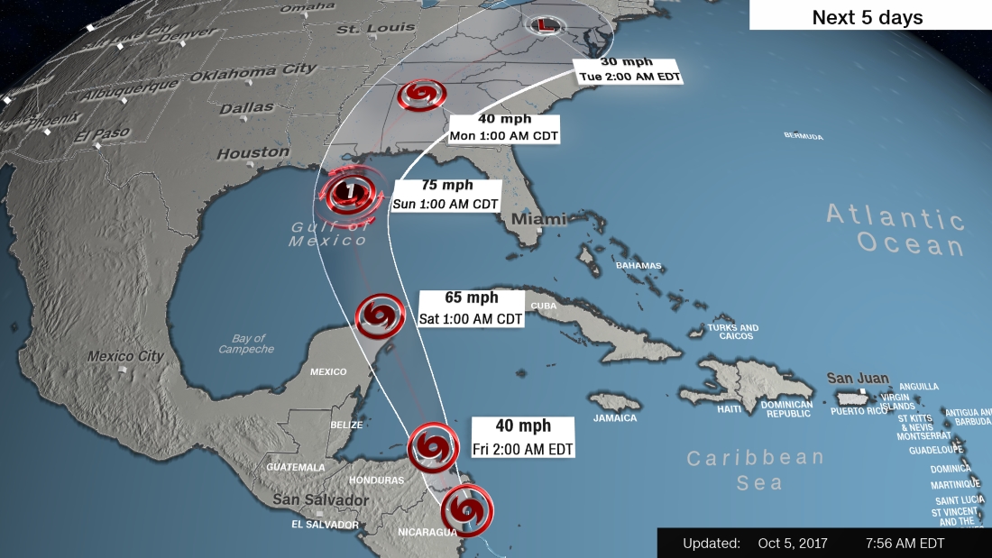
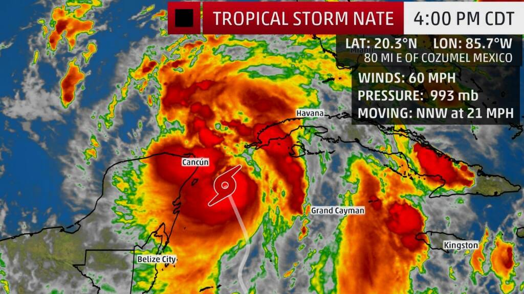
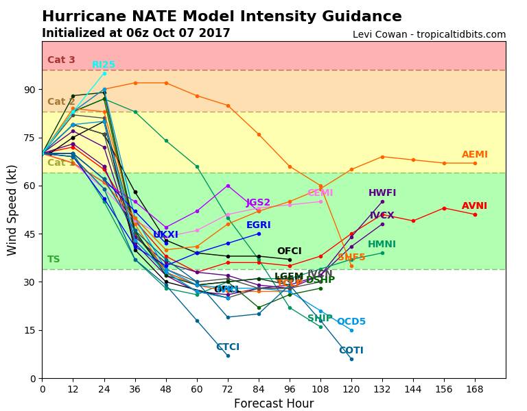
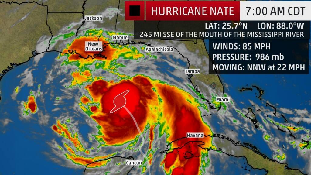
The eye of the storm was expected to pass late Saturday or early Sunday about 50 miles east of New Orleans. Over the warm waters of the northwestern Caribbean Sea, Nate was forecast to gain strength as it approaches the Yucatan Peninsula in Mexico later Friday and possibly strengthen into a Category 1 hurricane by the time it makes landfall.

A tropical storm warning was issued late Friday morning for New Orleans and Lake Pontchartrain, west to Morgan City, Louisiana.

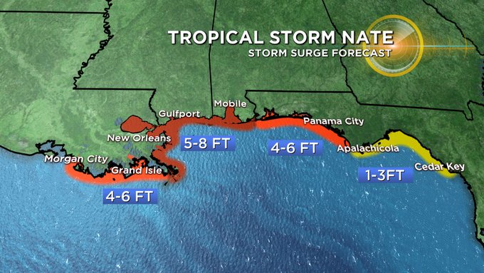
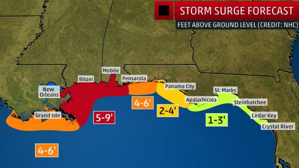
A a hurricane warning was issued from Grand Isle, Louisiana, to the Alabama-Florida border.

A storm surge warning was put in place from Morgan City to the Alabama-Florida line, as well as along the northern and western shores of Lake Pontchartrain.

maria_track.jpg


Louisiana
Of the city's 120 main drainage pumps, three major and nine smaller ones were offline Thursday night. Also, all 24 major pump stations had backup generators, as only three of five turbines that help power the city's oldest, most powerful pumps were available for service. The Louisiana Governor authorized 1,300 National Guard troops to mobilize ahead of the storm, with some headed to New Orleans to help monitor the pumps.

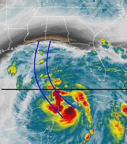
Central Gulf Coast, Tennessee, Southern Appalachian Mountains
The storm could drop 3 to 6 inches of rain, with 12 inches possible in some areas, from the central Gulf Coast north through Tennessee and the southern Appalachians through the weekend, possibly spawning flash floods.

Florida and Alabama
Though Florida remained largely out of the forecast cone, hurricane, tropical storm and storm surge watches were issued late Friday from the state's border with Alabama east as far as Indian Pass.

In Alabama, a statewide emergency declaration was signed and went into effect Friday morning. The move "frees up personnel and resources in case there is a need to respond to any storm related activity." The mayor of Mobile, Alabama warned residents Friday about storm surge. "We encourage citizens in low-lying areas to pay special attention to newscasts. There is a projected 4- to 7-(foot) storm surge. It will happen to coincide with high tide, which will give you additional water levels." Mobile officials were checking storm drains for debris, taking measures to avert power outages and deploying critical equipment. Shelters were prepared to open, if necessary.

Southeast Tennessee and Southwest North Carolina
The Knoxville area is likely to dodge the worst weather as the remnants of Tropical Storm Nate reach East Tennessee by Sunday. Rainfall of more than 4 inches is possible for southeast Tennessee and southwest North Carolina, with the potential for flooding in the headwaters of the French Broad and Pigeon rivers. Locally, 2-3 inches of rainfall is expected, beginning with scattered showers as early as Saturday night. The heaviest rains should fall Sunday afternoon and into Sunday evening.

http://www.cnn.com/2017/10/06/us/tropical-storm-nate-forecast/index.html
http://www.knoxnews.com/story/weath...ed-dodge-worst-tropical-storm-nate/740128001/
 
Jim Cantore lands in Gulfport, MS

http://www.nola.com/hurricane/index.ssf/2017/10/jim_cantore_lands_in_gulfport.html

A little humor:

A Gulfport attorney said he boarded a plane in Atlanta to head home to Gulfport Thursday afternoon (Oct. 5) and Jim Cantore was on it.

"Everybody looked at him and said, 'Oh no, not you!'

http://www.sunherald.com/news/weather/hurricane/article177307481.html
I found that article hilarious. It raised my confidence level a notch, too, as I've suspected a slight eastern jog since yesterday. I don't wish the storm on anyone, but as long as the NOLA area is on the dry side of the storm (west side), the City proper might be spared heavy rain, and hence flooding problems. :crossfingers:

Sent from my SAMSUNG-SM-G930A using Tapatalk
 
Storm surge predictions show New Orleans at 5-8 feet. Higher rainfall levels will be on the strong side, in MS/AL. Its predicted to be at a cat 1 intensity and models are very consistent on the track, including NHC. Radar shows Nate showing some spin.

www.spaghetti models.com
7fc504d7ccd33ce496fc7d53647fb9f2.jpg
9e2cb1c87cb32ab1b498d5ea3537c105.jpg
1ab43433b6487712eef61d1c3f7022e4.jpg
05b0d37c0fc511204f5ef9a33826a8ba.jpg
50eb5eace9bd924fc4c7725325c8a3f9.gif


Sent from my VK815 using Tapatalk
 
Nate is at 60 mph winds, not quite hurricane status. It will reach hurricane status as it approaches US landfall. Hurricane warnings are posted from New Orleans, across MS/AL coast.

Www.spaghetti models.com
6e006734c0c18fe68f359b3e800e3856.jpg
c7d0c880c20713acc34e340cc74dc39c.jpg
716be5950f6037de3bb12e6643ba53fa.jpg


Sent from my VK815 using Tapatalk
 
Time will tell if it stays on this track...today's best estimate.

Www.spaghetti models.com
48ddbcfc168548be3355466ff8ade690.jpg


Sent from my VK815 using Tapatalk
 
Time will tell if it stays on this track...today's best estimate.

Www.spaghetti models.com
48ddbcfc168548be3355466ff8ade690.jpg


Sent from my VK815 using Tapatalk


Henry2326, I keep thinking how exhausted you must be from the constant updates you've done throughout all these hurricanes!

Yet, here you are, not missing a beat. Like a beacon shining.

Thank you so much for giving of yourself and your time to keep us all updated.

I salute your commitment and resolve...
 
Mandatory citywide curfew to begin at 7 p.m. Saturday

Updated on October 6, 2017 at 10:55 PM
Posted on October 6, 2017 at 7:26 PM

[...]


* During the curfew, residents are asked to stay off of local roadways and shelter in place. This includes avoiding areas prone to street flooding during rain, the NOPD noted.

* Exceptions include: those traveling to and from work and essential safety personnel. Both of these groups will be allowed to travel on city streets for as long as officials deem it safe to do so.

* Underpasses will be barricaded beginning at 6 p.m. Saturday, according to the New Orleans Police Department. The barricades will continue until underpasses become safe again for travel.

* Public transportation, including city buses and streetcars, will be suspended once winds exceed 35 mph.

* At a certain point, officials expect weather conditions to make travel impossible for first-responders, even in answer to emergency calls.

* The New Orleans Police Department will be enforcing the curfew. In a Friday night statement, the NOPD said officers would take "strong enforcement action" against anyone found circumventing barricades or violating curfew. Neither city or NOPD officials provided details on what "strong enforcement action" would entail.

http://www.nola.com/hurricane/index.ssf/2017/10/mandatory_citywide_curfew_to_b.html


Sent from my SAMSUNG-SM-G930A using Tapatalk
 
Thanks for the updates, Henry. Bessie, I am trying to keep watch over you .... stay ready.

JazzTunes, I love your presence on these boards. you are always so kind to everyone!
 
Here I've been thinking how draining these hurricanes have been, I can't imagine the emotional toll being in the path must be!

Thank you Henry2326 for keeping us all up to date!

Henry2326, I keep thinking how exhausted you must be from the constant updates you've done throughout all these hurricanes!

Yet, here you are, not missing a beat. Like a beacon shining.

Thank you so much for giving of yourself and your time to keep us all updated.

I salute your commitment and resolve...
 
Thanks everyone. I hope you are all safe.

Nate is now a hurricane at 85 mph winds. It is now forecast to be a cat 2 at landfall. Forecasted path has not changed overnight.

Mike on Mike's Weather page says "Most all the action is to the east of Nate. Surge biggest threat, followed by wind... could be 90-95 at landfall late tonight."

Www.spaghetti models.com
4f32b0d5138afa14271a6296c9837188.jpg
79b40b89401169b4e4ef92fcf42efc02.jpg
cb075cdb8aa0b42105173e6212a57a38.jpg
4f71d8cb73f5e8d841f4da3de47228c7.gif


Sent from my VK815 using Tapatalk
 
Storm surge will be a huge impact from Nate. Estimates have slightly increased from yesterday.

Www.spaghetti models.com
30375244c2a5dad2347ea01332477d6b.jpg


Sent from my VK815 using Tapatalk
 
Please stay vigilant if you live in the cone. As you can see from the various model runs and as we know from previous experience, there is no certainty concerning landfall predictions.
6b97feeafc7bb9239a9d3f168b6a1c4d.gif


Sent from my VK815 using Tapatalk
 

Members online

Online statistics

Members online
121
Guests online
4,366
Total visitors
4,487

Forum statistics

Threads
592,544
Messages
17,970,722
Members
228,804
Latest member
MeanBean
Back
Top