Hurricane Nate - October 2017

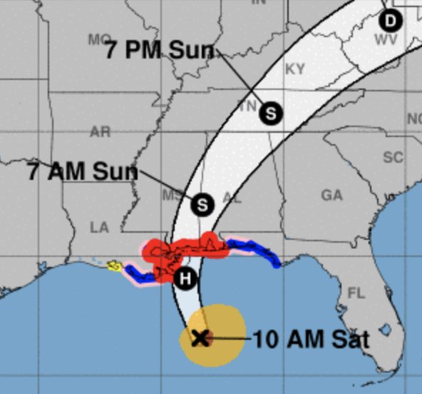
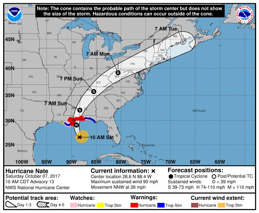
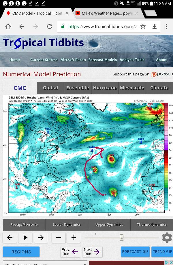
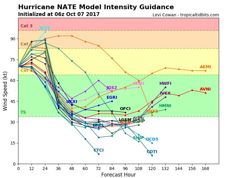
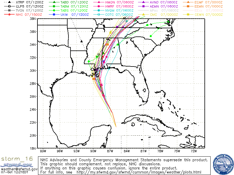
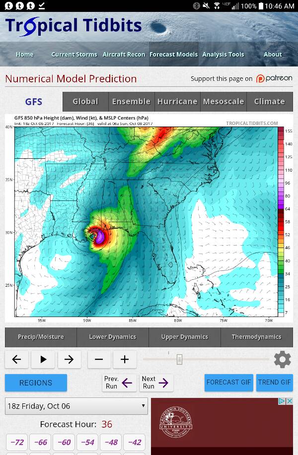
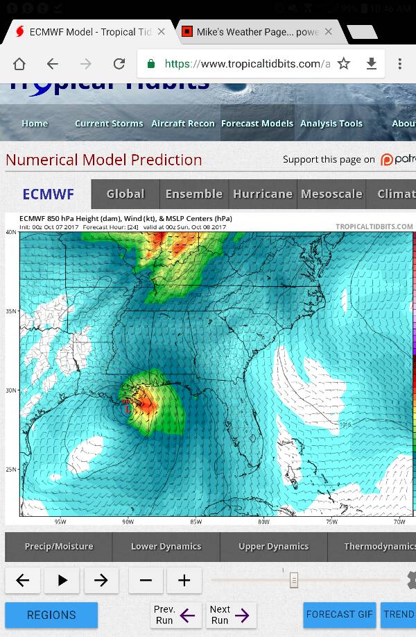
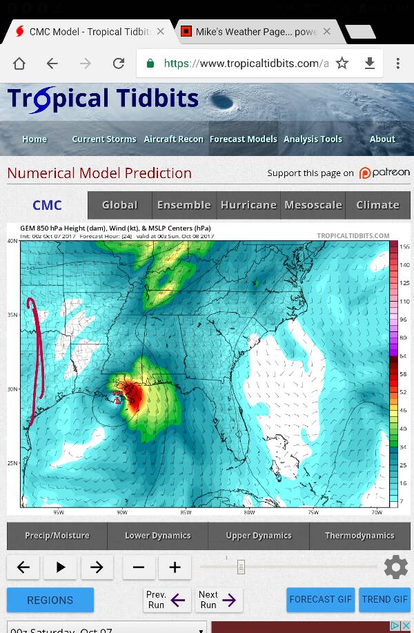
The overnight models shifted slightly west from the NHC version. We typically see these shifts back and forth in the models.

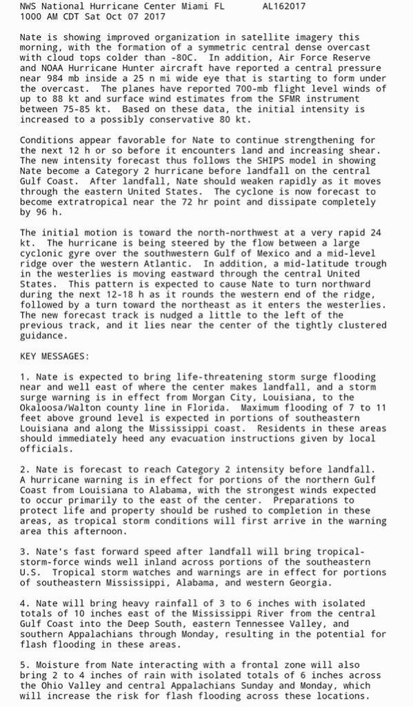
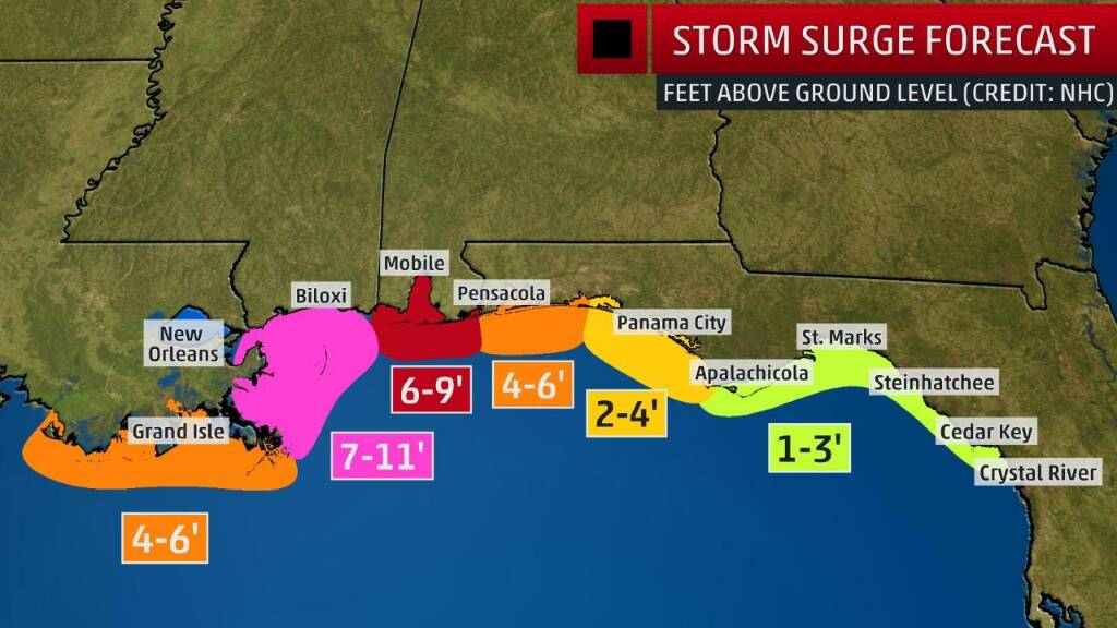
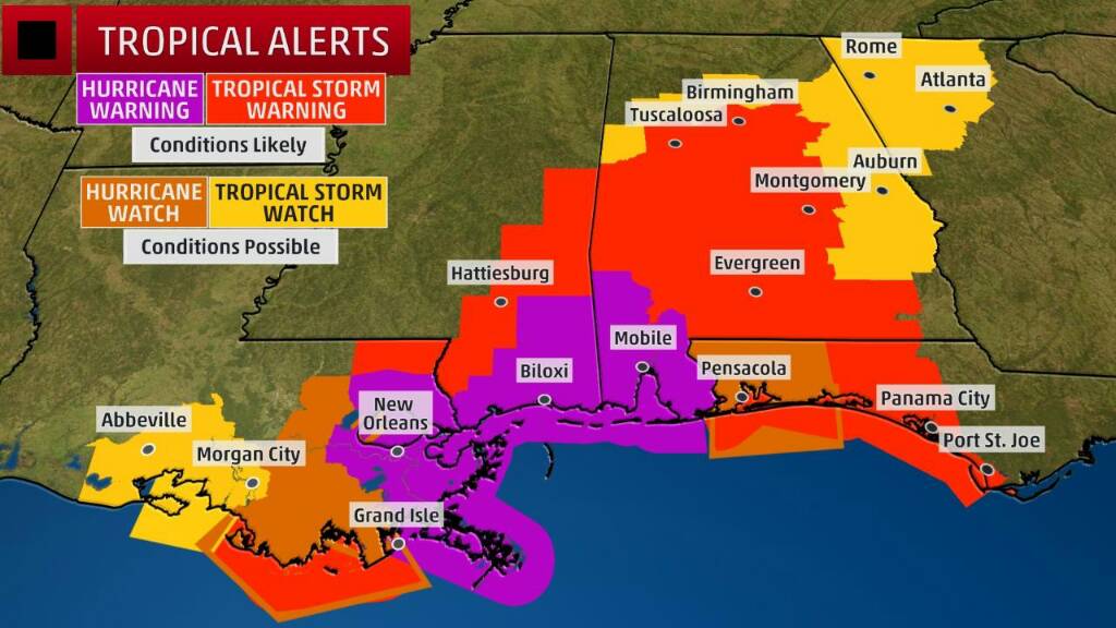
I'm happy to see mandatory curfew and mandatory evacuation in vulnerable areas of New Orleans. If the models below occur, significant flooding is possible east of the storm, which would now include New Orleans.

https://www.tropicaltidbits.com/ana..._uv850&runtime=2017100706&fh=18&xpos=0&ypos=0
92c148f6ad42aa3767fa1819d7242ac1.jpg
f7fc8d76341d6563ea7e05c487bbcf49.jpg
7e4b1dc0ea195e7c6429133ac6eb766d.jpg


Sent from my VK815 using Tapatalk
 
After the last post about the NHC not aligned, I went back to see the latest NHC forecast.

The 10:00 am forecast is now aligned with the other models with a slight jog West.

I will continue to watch in the coming hours for any coninuing movement westward.


47ef61fdabca14a54fbb740eacec760c.jpg
e998cc7eff1b953c5e0938be347e60e9.jpg


Sent from my VK815 using Tapatalk
 
Henry, any thoughts about the disturbance currently in mid-Atlantic west of the Canary Islands? It seems too far north to track westwards, so is this likely to head towards Europe?
 
Thank you Henry, JerseyGirl and Bessie.....I am concerned about storm surge from the lakes and the little river that runs behind the house and looks like a ditch most days. Bessie I am with you.....would love to keep electricity and also have a plan B....relatives with a generator...!!! :seeya:
 
Thank you Henry, JerseyGirl and Bessie.....I am concerned about storm surge from the lakes and the little river that runs behind the house and looks like a ditch most days. Bessie I am with you.....would love to keep electricity and also have a plan B....relatives with a generator...!!! :seeya:
Great to know you have access to a generator. Stay safe and watch those little rivers. In the past year, South Carolina, North Carolina, and Jax Florida saw those little rivers turn into raging monsters. Hoping for the best for you...

Sent from my VK815 using Tapatalk
 
Henry, any thoughts about the disturbance currently in mid-Atlantic west of the Canary Islands? It seems too far north to track westwards, so is this likely to head towards Europe?
Hi Mel- the Canadian model is the only one showing development of these systems. All three systems turn and move north to northeast, as Nate is pushing off the US.

https://www.tropicaltidbits.com/ana..._uv850&runtime=2017100700&fh=36&xpos=0&ypos=0
f254a9ad8af680b53e805b69ac63523e.jpg


Sent from my VK815 using Tapatalk
 
Hurricane Nate Strengthens as It Approaches U.S. Gulf Coast
by Phil Helsel and Chelsea Bailey

Some 13 million Gulf Coast residents were under threat as Hurricane Nate powered toward the mainland early Saturday, bringing with it rain and storm surges to parts of Louisiana, Alabama and Florida.

The hurricane, with maximum sustained winds of 90 mph, is now expected to make landfall on Saturday night between New Orleans and Mobile, Alabama, as a Category 2 storm, the National Hurricane Center said Saturday morning. It was about 180 miles south-southeast of the mouth of the Mississippi River, and was moving north-northwest at 26 mph, the hurricane center said.

"Nate is at our doorstep, or will be soon," New Orleans Mayor Mitch Landrieu said at a press conference Friday. A hurricane warning has been issued for the city, which is under a state of emergency...

https://www.nbcnews.com/news/weathe...rengthens-hurricane-it-approaches-u-s-n808606
 
Nate is continuing to intensify with estimates increasing to possibly a weak cat3. There is another slight jog to the west in the noon models.

There is a significant increase in estimates of storm surge.

http://spaghettimodels.com
844ba1e16852a7c350f960e6b4861ac7.jpg
ccb13e4676f5d48a42a4ef902245f505.jpg
05fa2cfe5111fa0256a2c91a56aee025.gif
88275dc1436b9bfc5f65efc95537abaf.gif


Sent from my VK815 using Tapatalk
 
NHC 1:00 pm advisory.....Nate at 90 mph and 982 pressure. Expecting continuing intensification to landfall.
7ffc76ffce21358a1921364ed4cf3b81.jpg
cd6de68d7a5392c16fc523c65f675b5b.jpg


Sent from my VK815 using Tapatalk
 
Rainfall level predictions east of the storm have increased since last night in the Mobile, AL area and most of southern AL.
ab35e4caac6cb894a6ab79326bd8b299.jpg
ea7a00266b0665eea0ca2ee03092c2e9.jpg


Sent from my VK815 using Tapatalk
 
Officials issue curfew for residents of Hancock Co., MS

Oct 7, 2017 11:43 AM

HANCOCK COUNTY, MS (WVUE) - Residents in the low-lying areas of Hancock County, Mississippi are currently under a mandatory evacuation order beginning at 7 a.m.

The evacuation order was issued by the Hancock County Emergency Management Agency in coordination with the Hancock County Board of Supervisors and the cities of Bay St. Louis, Diamondhead and Waveland.*

A curfew was also issued for residents in Hancock County starting Saturday at 9 p.m. and ending Sunday at 9 a.m.*

Hancock County Emergency Management Director Brian Adam says they are making sure that people understand the seriousness of the situation and are heeding their evacuation orders.

Officials will begin opening shelters for those residents who are evacuating in Hancock County Saturday morning. The first shelter will open at 7 a.m. in Kiln, MS at 18320 Hwy 43. A second shelter will open at 10 a.m. at 28290 Lee Town Road in Picayune, MS.

Those heading to the shelters should make sure to bring their own bedding, toiletries, drinks and snacks. They should also make sure to bring all required medications.*

Pets will not be allowed inside of the general population shelters.

http://m.fox8live.com/wvuefox8/db_354681/contentdetail.htm?contentguid=xqY0iGXG

Sent from my VK815 using Tapatalk
 
Jackson County, Miss., recommends voluntary evacuation due to Nate

Posted:*Oct 06, 2017 3:03 PM EDTUpdated:*Oct 06, 2017 3:03 PM EDT

JACKSON COUNTY, MISS. (WALA) -

The Jackson County Office of Emergency Services is strongly recommending a voluntary evacuation for all residents living in low-lying flood prone areas near any waterways, bayous, creeks, and drainages due to storm surge potential of 3-9 feet, or greater, above ground level in certain areas close to beach fronts and any inland waterways. This evacuation will be effective at 8 a.m. Saturday.*
*
Also, the Jackson County American Red Cross 361 Emergency Shelters will be opening at 8 a.m. Saturday. Residents going to a shelter should bring medication, pillow change of clothes, snacks and all necessary personal essentials. *The Red Cross website*www.redcross.org*provides information about shelter guidelines, hurricane preparation, and a downloadable hurricane app.*


Jackson County Emergency Shelters
*
Vancleave 361
**********Central Jackson County Shelter
**********5500 Ballpark Road
**********Vancleave, MS*
**********Phone: 228-826-3820
*
St. Martin 361
**********West Jackson County Shelter
**********13000 Walker Road
**********St. Martin, MS*
**********Phone: 228-872-8615
*
East Central 361
**********East Jackson County Shelter
**********18413 Hwy. 613
**********Hurley, MS*
**********Phone: *228-588-6995

http://www.fox10tv.com/story/365398...s-recommends-voluntary-evacuation-due-to-nate

Sent from my VK815 using Tapatalk
 
Evacuation Order in Gulf Shores

by Cayla Brewer

Saturday, October 7th 2017

Gulf Shores Mayor Robert Craft has issued an evacuation order for all properties in Emergency District 32 and all beachfront houses and duplexes within Emergency District 33. District 32 includes all properties along West Beach Boulevard located west of Little Lagoon Pass/Lee Callaway Bridge. District 33 encompasses the west beach area between West 8th Street and Little Lagoon Pass/Lee Callaway Bridge.*

Hurricane Nate continues significant intensification and is now forecast to make landfall as a Category 2 hurricane. Beachfront and low-lying areas will experience life-threatening storm surge of 6 to 9 feet above normally dry ground and potentially catastrophic hurricane force winds.*

All access to the W.C. Holmes Bridge on State Highway 59 will be restricted once sustained winds reach 45 mph which is anticipated as early as 7 p.m. tonight. Anyone remaining in areas under evacuation orders should understand all emergency response will be suspended once conditions deteriorate to unsafe levels.*

TThe City of Gulf Shores, in conjunction with the City of Orange Beach, will enforce a mandatory curfew beginning at 8 p.m. Saturday through 6 a.m. Sunday. This curfew is in place for the safety of citizens due to expected hurricane-force winds during this time. All vehicles should stay off of roadways until the curfew has expired. Local businesses are asked to prepare and adjust for proper closing times to allow for employees to return home safely before the curfew begins.

http://local15tv.com/news/local/mandatory-evacuations-in-gulf-shores

Sent from my VK815 using Tapatalk
 

Members online

Online statistics

Members online
104
Guests online
4,361
Total visitors
4,465

Forum statistics

Threads
592,546
Messages
17,970,761
Members
228,805
Latest member
Val in PA
Back
Top