Is obvious I think. They look and see you cannot walk of path without knowing. You cannot fall of path. If you can fall of path you can be seen. They do not see anything. Esther Dingley walked of path and keeped walking of path? Why is this? They maybe know other things also. A person lost in mountains is an accident. But they say no at first. No way. Why? Is strange. Also animals carry a bone for miles then leave on track? Why? Animals do not do this. They eat where find or take to close place. They look for Esther Dingley to show murder in my opinion. Maybe accident but very strange I think she is killed by person she is known in my opinion.Interesting. Well we can't rule anything out. What makes you think the police are working on this as the most likely scenario?

You are using an out of date browser. It may not display this or other websites correctly.
You should upgrade or use an alternative browser.
You should upgrade or use an alternative browser.
Found Deceased Spain - Esther Dingley, from UK, missing in the Pyrenees, November 2020 #6
- Thread starter FrostOwl
- Start date
- Status
- Not open for further replies.
RickshawFan
Verified Outdoor Recreation Specialist
- Joined
- Jun 9, 2013
- Messages
- 10,691
- Reaction score
- 52,065
Snipped for focusMaybe, I think in my opinion, she went back down hill
This is an interesting opinion I don't believe we have considered yet. You have the opinion ED went on the trail up to the Port de la Glère and then she went down again. As you mention, judging from your experience, you don't think ED went off the trail by mistake.
I have some questions, though. In your opinion, did she go up in France and down in Spain? Or up in France and down in France? Or up in Spain and down in Spain? Or up in Spain and down in France? This makes a big difference to your picture.
My own opinion is she went up in Spain and began to go down in France. But perhaps you have a different idea.
Then, you are saying, something terrible happened when ED was down the mountain, and a bad person took a bone up the mountain?
I have some difficulties with that. I think that person would be doing too much unnecessary climbing on a tedious trail where they could have an accident. If he or she wanted to scatter the remains, they could leave them next to the trail in an easy place.
Is obvious I think. They look and see you cannot walk of path without knowing. You cannot fall of path. If you can fall of path you can be seen. They do not see anything. Esther Dingley walked of path and keeped walking of path? Why is this? They maybe know other things also. A person lost in mountains is an accident. But they say no at first. No way. Why? Is strange. Also animals carry a bone for miles then leave on track? Why? Animals do not do this. They eat where find or take to close place. They look for Esther Dingley to show murder in my opinion. Maybe accident but very strange I think she is killed by person she is known in my opinion.Interesting. Well we can't rule anything out. What makes you think the police are working on this as the most likely scenario?
You ask if I broke law in France when working? Thank you but in my opinion is ok to say no.Did you hike up, or down, the Port de la Glere in France in November?
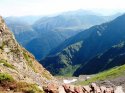
https://sp-images.summitpost.org/64...2.1.1&q=35&s=899b803068376a187e2fce8b20911c54Photo from Port de la Glère : Photos, Diagrams & Topos : SummitPost Note the cliff amidst all the scree as the trail goes forward. The switchbacks may no longer exist (see @otto 's maps). Note the green patches: this area will be dewy in summer and frosty in shoulder seasons (ED was firmly into winter).
This seems to be the very top of the path, just below Port de la Glère. The switchbacks descend roughly ESE, before the trail turns NE across the scree. I think this is the same part of the trail looking up from below:
http://wns.free.fr/randonnees/Pic_Sacroux/photos/1030256.jpg
See the reddish stone of the retaining walls of the switchback part of the trail. The aerial photography on the géoportail website dates from 2019, so the path is still there. In fact the presence of grass and a well defined path across the scree suggest to me that the surface is stable, although very steep.
There is a large fallen rock slab visible on Googlemaps just below the Port, and a jumble of large rock debris at the bottom of the scree slope, just above the grassy slopes of the cirque. Are those the locations you're suggesting?
Last edited:
You ask if I broke law in France when working? Thank you but in my opinion is ok to say no.
I'm asking whether you ascended or descended the Port de la Glere trail in France in November. You mentioned that you hiked the easy trail in November, so I'm curious whether you went up or down that section of the trail.
RickshawFan
Verified Outdoor Recreation Specialist
- Joined
- Jun 9, 2013
- Messages
- 10,691
- Reaction score
- 52,065
The photo I cited is from 2010. I believe that's the same one you're showing?https://sp-images.summitpost.org/64...2.1.1&q=35&s=899b803068376a187e2fce8b20911c54
This seems to be the very top of the path, just below Port de la Glère. The switchbacks descend roughly ESE, before the trail turns NE across the scree. I think this is the same part of the trail looking up from below:
http://wns.free.fr/randonnees/Pic_Sacroux/photos/1030256.jpg
See the reddish stone of the retaining walls of the switchback part of the trail. The aerial photography on the géoportail website dates from 2019, so the path is still there. In fact the presence of grass and a well defined path across the scree suggest to me that the surface is stable, although very steep.
There is a large fallen rock slab visible on Googlemaps just below the Port, and a jumble of large rock debris at the bottom of the scree slope, just above the grassy slopes of the cirque. Are those the locations you're suggesting?
On Otto's maps, it didn't look as though there was much left in the way of switchbacks. Also, even if the switchbacks in the 2010 photo are still there, not the lack of switchbacks straight down the trail in the grey area (unless that's water scarring).
We did not break law. But if we ever went there one time it was close to this way. Park, walk, big paths most of way, cannot fall of, easy. In Esther Dingley week path was still easy I know this. Some places with snow but very hard to die here. Is all. Esther Dingley did not fall of path I think. Also police in my opinion.I'm asking whether you ascended or descended the Port de la Glere trail in France in November. You mentioned that you hiked the easy trail in November, so I'm curious whether you went up or down that section of the trail.
I do not know if France or Spain. I think maybe same way up and down so Spain. Maybe back down and not go to Le Glere. Just down from PdS to road. But maybe not. If Spain Esther Dingley could be far from there dropped near road. They will not find her by looking in my opinion. If France then closer I think in hills in my opinion and maybe they find by looking. No chance of accident dropping bone now I think. Murderers do not care like this in my opinion.Snipped for focus
This is an interesting opinion I don't believe we have considered yet. You have the opinion ED went on the trail up to the Port de la Glère and then she went down again. As you mention, judging from your experience, you don't think ED went off the trail by mistake.
I have some questions, though. In your opinion, did she go up in France and down in Spain? Or up in France and down in France? Or up in Spain and down in Spain? Or up in Spain and down in France? This makes a big difference to your picture.
My own opinion is she went up in Spain and began to go down in France. But perhaps you have a different idea.
Then, you are saying, something terrible happened when ED was down the mountain, and a bad person took a bone up the mountain?
I have some difficulties with that. I think that person would be doing too much unnecessary climbing on a tedious trail where they could have an accident. If he or she wanted to scatter the remains, they could leave them next to the trail in an easy place.
Mandalas
Psychology Postgrad.
- Joined
- Jul 2, 2020
- Messages
- 346
- Reaction score
- 2,345
@Pahorb I do not think @otto is suggesting you broke the law, only if you had experience of hiking a certain trail at a particular time of year (ie. November). I'm not sure where the idea of breaking the law comes from, possibly a mistranslation?We did not break law. But if we ever went there one time it was close to this way. Park, walk, big paths most of way, cannot fall of, easy. In Esther Dingley week path was still easy I know this. Some places with snow but very hard to die here. Is all. Esther Dingley did not fall of path I think. Also police in my opinion.
I speak fluent French if that is any help, happy to translate if useful.
Ruthbullock
Well-Known Member
- Joined
- Oct 27, 2016
- Messages
- 1,568
- Reaction score
- 7,137
I could be wrong, but I’m guessing he’s spainish.@Pahorb I do not think @otto is suggesting you broke the law, only if you had experience of hiking a certain trail at a particular time of year (ie. November). I'm not sure where the idea of breaking the law comes from, possibly a mistranslation?
I speak fluent French if that is any help, happy to translate if useful.
RickshawFan
Verified Outdoor Recreation Specialist
- Joined
- Jun 9, 2013
- Messages
- 10,691
- Reaction score
- 52,065
Thanks for that link! I was looking for it.We did not break law. But if we ever went there one time it was close to this way. Park, walk, big paths most of way, cannot fall of, easy. In Esther Dingley week path was still easy I know this. Some places with snow but very hard to die here. Is all. Esther Dingley did not fall of path I think. Also police in my opinion.
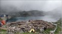
Note the flowers in one photo. They are set into a crevice in a batch of loose large-ish rock. Imagine what would happen if something died on top of rocks like this.... the bones would drop down into the substrate.
In the other, note how steep that trail is down the scree. And then it disappears out of sight.
Wikiloc | Picture of Port De La Glere (3/6)
Attachments

RickshawFan
Verified Outdoor Recreation Specialist
- Joined
- Jun 9, 2013
- Messages
- 10,691
- Reaction score
- 52,065
Maybe Basque?I could be wrong, but I’m guessing he’s spainish.
Grouse
Well-Known Member
- Joined
- Dec 2, 2020
- Messages
- 1,137
- Reaction score
- 6,321
Maybe accident but very strange I think she is killed by person she is known in my opinion.
While I wouldn't want to be white-washing the article, or be party to any misguided effort to protect any subject, can you explain where you are going with this theory? If indeed it was a murder, why are you so sure not a stranger/hunter?
RickshawFan
Verified Outdoor Recreation Specialist
- Joined
- Jun 9, 2013
- Messages
- 10,691
- Reaction score
- 52,065
I thought we dispensed with the hunter motif a long time ago, because it involved a substantial list of improbabilities? It doesn't sound like that's where Pahorb is going with this. The stranger motif would definitely be worth re-visiting IMO, since it hasn't made its way into this thread IIRC since the skull discovery IIRC. So, yeah, @Pahorb , why do you think someone ED knew might have harmed her, and why do you think not a stranger? That's a curious idea. I guess the police have considered it, but we don't know what they're investigating. This investigation does seem to be taking a long time, though.While I wouldn't want to be white-washing the article, or be party to any misguided effort to protect any subject, can you explain where you are going with this theory? If indeed it was a murder, why are you so sure not a stranger/hunter?
Right. The same part of the trail, from above and below.The photo I cited is from 2010. I believe that's the same one you're showing?
The switchbacks in the picture come down the rock slope above the scree, directly below the Port. They're still there. The trail across the scree is quite straight at first, but traverses the slope, before zigzagging again. This is visible on the IGN géoportail aerial and topo mapping.On Otto's maps, it didn't look as though there was much left in the way of switchbacks. Also, even if the switchbacks in the 2010 photo are still there, not the lack of switchbacks straight down the trail in the grey area (unless that's water scarring).
The trail is steep, but it disappears around a corner (effectively) because of the perspective of the photograph, not off a cliff. The debris field at the bottom of the slope would be the natural place to look for anyone falling on the scree. This area was Esther's expected destination and must have been searched closely. It's hard for me to believe that there was no sign of her on this slope just days after her disappearance if she died on the scree. Bones might disappear into crevices between the rocks given enough time, but a rucksack and walking poles wouldn't. This is one of the most open parts of her intended route.Note the flowers in one photo. They are set into a crevice in a batch of loose large-ish rock. Imagine what would happen if something died on top of rocks like this.... the bones would drop down into the substrate.
In the other, note how steep that trail is down the scree. And then it disappears out of sight.
RedHaus
Well-Known Member
- Joined
- Dec 13, 2020
- Messages
- 829
- Reaction score
- 6,624
SBM & BBMSo, yeah, @Pahorb , why do you think someone ED knew might have harmed her, and why do you think not a stranger? That's a curious idea. I guess the police have considered it, but we don't know what they're investigating. This investigation does seem to be taking a long time, though.
I have not dismissed the possibility that ED was murdered, although I think it is remote for the reasons discussed here, despite DC's insistence a third party was involved.
That said, I found an article today about the Meredith E. (ME) case - abducted and murdered by a man while hiking. The serial killer had done this before. There are other articles that detail how poor Meredith was murdered, but I'll spare you from seeing that detail. The article, below, is hard to read but less so than others.
I will add, since it is not in this article, ME innocently hiked with her murderer for some amount of time until he tired (he was 61). He stopped and ME continued up the steep trail. The man waited for her to descend down the same trail to abduct her. That is just a terrifying scenario for me to consider.
I certainly can envision ED pairing up with a stranger she encountered on the trail to hike together - she did that several times previously during her solo sojourn. She could have met someone at Hospice de France or Cabane de la Besurta for instance. And if it was an evil person, then she may have put herself at grave risk of harm.
Ten years later, hiker’s murder still haunts those closest to case
The other problem I see with this idea is that we still need to account for how she came to be descending the scree from Port de la Glère when her last known location was the Pic de Sauvegarde.IMO the odds are ED was descending the scree slope below the PdelaG where she was found.
In my view, the only destination that makes sense for the night of the 22nd is the refuge de Venasque. She couldn't have reached the Port de la Glère before dark on the 22nd, so for her to fall on the scree while descending would require her to either return to Spain on the 23rd, navigate the ridge along the border, or attempt to descend the scree having first climbed it. None of these options makes any sense to me.
We did not break law. But if we ever went there one time it was close to this way. Park, walk, big paths most of way, cannot fall of, easy. In Esther Dingley week path was still easy I know this. Some places with snow but very hard to die here. Is all. Esther Dingley did not fall of path I think. Also police in my opinion.
ED May have left the path deliberately in order to answer a call of nature and then lost her way back to the main track (like Geraldine Largay). In other words she didn’t necessarily “fall off” the track.
Also, on 19th November she posted the following on the Esther & Dan Facebook page.
“Today was a very mixed day. I set off relaxed, thinking I had all the time in the world because the weather looked good and the forecast had been also good. But slowly I found myself racing the weather. I had to release any expectations to my plans of climbing the 2550m peak and staying out for another night away... But it could just blow through I thought so I decided to give it a try. My fears and doubts started to set I with the forest few spots of rain and the wind picking up. It wasn't helped that although on this hike I wasn't climbing my way up snow and ice, I was struggling with a different challenge, disappearing paths and confusing goat/sheep tracks taking me of track and finding myself continually have to stop to check the map and haul myself up the mountainside to get back on track. My self doubt in my decision to try was increasing each time I found myself off track.......
RedHaus
Well-Known Member
- Joined
- Dec 13, 2020
- Messages
- 829
- Reaction score
- 6,624
S & BBMIn my view, the only destination that makes sense for the night of the 22nd is the refuge de Venasque.
Hi @OEJ-JEO.
I do think there is a good possibility, although none of us have any data to support theories of where ED went after her WhatsApp call with DC at about 16:00 on 22/11, that ED went back down to Cabane de la Besurta to spend the night of 22/11. She had stayed there the night before, per the Dossier, and so it was familiar to her. That would also support a clockwise loop of her itinerary if she then proceeded towards Port de la Glere the morning of 23/11... from there...????
I'm not married to that scenario. In fact, I have previously proposed ED descended from the summit of Pic de Sauveguarde and committed suicide by drowning (with rocks in her pack) in Boum de Vanesque the evening of 22/11 after watching the sunset at the summit. I may be the only one that considers that scenario, but it haunts me.
I thought we dispensed with the hunter motif a long time ago, because it involved a substantial list of improbabilities? It doesn't sound like that's where Pahorb is going with this. The stranger motif would definitely be worth re-visiting IMO, since it hasn't made its way into this thread IIRC since the skull discovery IIRC. So, yeah, @Pahorb , why do you think someone ED knew might have harmed her, and why do you think not a stranger? That's a curious idea. I guess the police have considered it, but we don't know what they're investigating. This investigation does seem to be taking a long time, though.
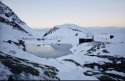
It is possible Esther met someone at the Refuge Venasque and walked on with them. I know Dan said there was no evidence when he visited and no visitor book. However we know workmen were there when it was usually unguarded in October 2020, and had already brought up some equipment/materials in preparation of building the new refuge. It wasn't good weather then - November 2020 was much better. So they may well have brought up more stuff then, and met, or saw her with someone. Lockdown escapees/hunters could also have stayed but most wouldn't admit it due to the lockdown exercise restriction of 1km distance from home.
(images with snow 14th and 15th October 2020, image without snow from June this year)
Attachments
- Status
- Not open for further replies.
DNASolves
Online statistics
- Members online
- 196
- Guests online
- 3,318
- Total visitors
- 3,514
Totals may include hidden visitors.