CO - Dylan Redwine missing from Vallecito ***SEARCH DISCUSSION ONLY***

Status
Not open for further replies.
My husband and I have had discussions about this. Google Earth is constantly updated. You can see the wreath on my front door change from season to season. I do believe there are satellites that have captured images of crimes while being committed. I just don't believe we little people would be considered worthy of spending the time or money to review what is captured by satellite.

Wondered about this also.

Google has caught numerous "crimes" of varying degrees on their cameras. Here's a link:
http://www.criminaljusticeschools.com/blog/20-crimes-caught-on-google-street-view/
 
Hey Lash, your point is valid. Do you live in a city ? Because I live in a fairly rural area and my home's google image is updated more like every several months, possibly even yearly. In a busy area with more changes, they probably update more and in a really isolated area like the mountain top roads with no homes on them, who knows how often the updates are ! Just thinking out loud.

OR I am not using the same map program you are talking about . I'm a super techno idiot so that latter could be the case .

I was curious so checked my home on google earth and google street view, I live in the suburbs of a capital city. I discovered that the images are more than 2 years out of date. the home across the road that is at least 3/4 years old was still being built and my old car was in my driveway, I changed cars march 2011.
 
I had a thought...

could there be more than one "dumping" ground of Dylan?

could some of the remains be in another location?

Like near the perp's workplace, for example?

:waitasec:
 
My husband and I have had discussions about this. Google Earth is constantly updated. You can see the wreath on my front door change from season to season. I do believe there are satellites that have captured images of crimes while being committed. I just don't believe we little people would be considered worthy of spending the time or money to review what is captured by satellite.

Google Maps and Google Earth are wonderful tools! I do believe that it is well worth looking at both tools for sleuthing. Any type of video or photographic evidence captures a moment in time. I have found evidence in a few cases and have turned it over to LE. Here is a guide that I posted here on WS, in the Internet Tips section.
[ame="http://www.websleuths.com/forums/showthread.php?t=197262"]http://www.websleuths.com/forums/showthread.php?t=197262[/ame]

If there is a blurry image, you can try a program link that I posted in the same Tips section, that helps unblur images. The program is called Smartdeblur
[ame="http://www.websleuths.com/forums/showthread.php?t=198411"]http://www.websleuths.com/forums/showthread.php?t=198411[/ame]

On this case, you might be able to find some clues in posted articles to help you start. For example, the articles say that Dylan's bones were found almost 10 miles from his home, off of Middle Mountain Road. You could start by creating a 10 mile radius around the home and see where it intersects with the road. There you have narrowed your search. I believe that Google Earth has that area on its July 2013 images. Click the history button at the top and you can toggle between dates to look for clues like disturbed earth. It can be time consuming, but clues can be found in some cases. In some areas, you can even get a ground level idea of the territory. If you know how many miles that Dylan's bones were found up from the lake, then you can drag the destination point until it gets to that number of miles. If you are looking at a house, start clicking on the windows and look inside. Sometimes the algorithm gets messed up and faces and license plates do not get blurred. This isn't just me guessing, I have found clues on other cases, and I think that it is possible for other people to do the same!
 
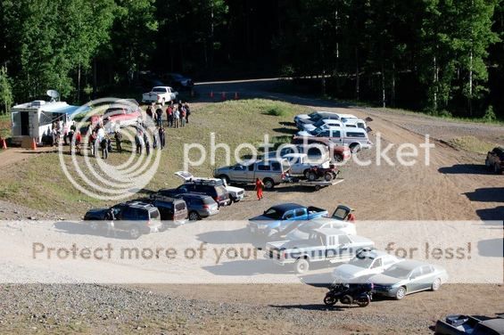
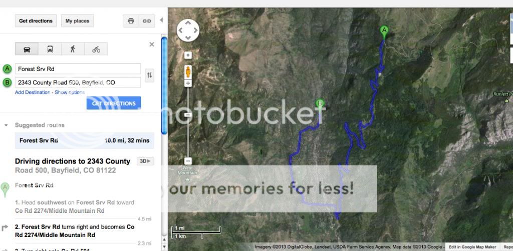
I have already posted this information on the Forensics Thread, but I thought it was relevant to the Search Thread as well. Here is the basic search information, and the Google Maps link showing the search staging area. This will give a basic idea of the 10 mile driving distance from MR's house to the furthest point where MR mentioned that they found DR's remains. You can use the Google Maps link below to start at the staging area, or you can go into Google Earth and look around there. I read that MR mentioned that the bones (shoulder, leg, fingertip and a few unknown) were found spread out between a 1.5 to 2 mile stretch. I am guessing that that would be between mile 8 and mile 10 (from MR's house) on Middle Mountain Rd. The staging area seems to be set up in the middle of the two mile stretch, at 9.2 miles from MR's home.

According to the Durango Herald:
"The remains were found in a drainage about 8 to 10 miles from the father's house, through the rural road system, Bender said. It is closer by a straight line. Bender declined to be specific about exactly where the remains were found. “It was roughly halfway up Middle Mountain Road,” he said."
http://www.durangoherald.com/article/20130627/NEWS01/130629581/0/news01/Dylan-Redwine%27s-remains-found

The search staging site appears to be located 9.2 miles from MR's house.

Google Maps Staging Site:
https://maps.google.com/maps?saddr=Middle+Mountain+Road,+Bayfield,+CO&daddr=Vallecito+Lake,+San+Juan+National+Forest,+Colorado&hl=en&ll=37.482227,-107.526943&spn=0.001207,0.002256&sll=37.697916,-107.535353&sspn=0.01017,0.013797&oq=middle+mountain&mra=ls&t=h&z=19

The 8 mile mark up Middle Mountain Road, would basically be a straight line East. This is a map from MR's house up to the 10 mile mark, turnout.
[URL=http://s1294.photobucket.com/user/Sasquatch60/media/DylanRedwine/googlemaps10mile_zpse2410d99.jpg.html][/URL]
 
here is the trailhead map of Middle Mountain

http://www.staythetrail.org/maps/photomap.php?trail_id=117&sv=0

http://www.staythetrail.org/maps/viewtrail.php?trail_id=117&sv=0

I read on another site (don't recall the link right now) where Dylan's remains were located closer to trailhead 810.

If it's #810, I mapped it (via your links thank you). It is right where I saw the closest to MR's house and to Middle Mountain via roads. Tucker Lane is one of the closests to Middle Mountain & to #810 by feet, I believe. It's very narrow to cross from back in there. Mostly roads or dirt roads? 200 to 300' from each other.

http://goo.gl/maps/GzP7J

MR lives approx. 2.6 miles from Tucker Lane, Tucker lane at the end of it is 200 to 300' from Middle Mountain & Trail marker #810.

eta, sorry, I've been away if this is a repeat.
 
If it's #810, I mapped it (via your links thank you). It is right where I saw the closest to MR's house and to Middle Mountain via roads. Tucker Lane is one of the closests to Middle Mountain & to #810 by feet, I believe. It's very narrow to cross from back in there. Mostly roads or dirt roads? 200 to 300' from each other.

http://goo.gl/maps/GzP7J

MR lives approx. 2.6 miles from Tucker Lane, Tucker lane at the end of it is 200 to 300' from Middle Mountain & Trail marker #810.
Weird. I get a different place for 810. I find it is farther North. See Attached.

It is exactly 10 miles to that point, and where the orange/red truck was noticed in the pictures. I'm thinking it's just a guess, like all we have.
 

Attachments

  • ToTrail 810MVUM.jpg
    ToTrail 810MVUM.jpg
    56.6 KB · Views: 15
  • ToTrail 810.jpg
    ToTrail 810.jpg
    38.3 KB · Views: 12
  • ToTrail 810Satellite.jpg
    ToTrail 810Satellite.jpg
    99 KB · Views: 15
  • ToTrail 810SatelliteZoomed.jpg
    ToTrail 810SatelliteZoomed.jpg
    131.8 KB · Views: 15
Weird. I get a different place for 810. I find it is farther North. See Attached.

It is exactly 10 miles to that point, and where the orange/red truck was noticed in the pictures. I'm thinking it's just a guess, like all we have.

I agree with you Ghostwheel! Thanks for posting the great images. I have been toggling between the satellite, trail map and terrain images. Now I see the Bear Creek that you were talking about. You are right, that the public does not know the exact location where the remains were found. These maps do give us more info to go on though. The other search photos released, show SAR on steep slopes. I wonder if those were taken directly below the 810 trail.
 
Weird. I get a different place for 810. I find it is farther North. See Attached.

It is exactly 10 miles to that point, and where the orange/red truck was noticed in the pictures. I'm thinking it's just a guess, like all we have.

I used the link above from PC of the trails. There was an option to get directions and yes it took me miles farther but I had remembered looking at the map last week or so and posted how close Tucker Lane was to Middle Mountain Road. The closest road I saw to cross possibly from 2300 CR 500 to Middle Mountain. Then to map it and see how close Tucker Ln & the trail mentioned, 810 via the link, it's right by each other.

Yes, it is weird.

I saved most of the info and will post what I mapped tomorrow.
 
I agree with you Ghostwheel! Thanks for posting the great images. I have been toggling between the satellite, trail map and terrain images. Now I see the Bear Creek that you were talking about. You are right, that the public does not know the exact location where the remains were found. These maps do give us more info to go on though. The other search photos released, show SAR on steep slopes. I wonder if those were taken directly below the 810 trail.
If you toggle at Bear Creek to satellite or Google Earth, you can see one of the concrete culverts coming out from under the road. I keep looking for another one of those and haven't found one yet. Let me know if you do.
 
MR doesn't strike me as a very computer oriented person. IOW, he doesn't strike me as a person whose first instinct is to do google searches for information or be on social media, etc. So I am not sure how helpful his computer is in that way.

I would be very surprised to learn that MR's computer had any signs of him having researched the area in which Dylan was found. JMO.

I don't think he researched the area he was found for I believe its a place he knows well. As I understand it he has an ATV and im sure he has been out on that mountain many many times even with his son!


And I Think MR knows computers very well!

All JMO
 
<bringing over from closed thread> I asked this last night, at the wrong time.

DOES anyone know or have confirmation that Mark was driving his KNOWN trucks to pick up Dylan?

Until then, assumptions and debate about his two trucks is limiting the discussion.

Wonder if LE has thought of this? I understand McD's HAD NO accurate digital image. Did mark have access to work truck?

A company truck ("just got in to durango" comment )to exchange Monday morning @ payroll? Why not? WE don't know for certain, do we? Dylan may not have thought unusual.
 
I don't think he researched the area he was found for I believe its a place he knows well. As I understand it he has an ATV and im sure he has been out on that mountain many many times even with his son!


And I Think MR knows computers very well!

All JMO

I think most people, computer savvy or not, now know that google searches will be scrutinized after a suspicious death.

The location of the body does indicate to me that the perp knew the area. Especially with the gates closing in the winter, it was a fantastic place to hide a body until evidence was destroyed (through natural processes).

Does anyone have a reference that MR had an ATV, or is that just a rumor?

I'm not trying to be confrontational; I just think we should stick with known facts in drawing our conclusions. I'm not sure I would want to try use an ATV to transport a body over extremely rough terrain (well, for lots of reasons). If recent guesses as to the location of the remains are correct, the body was probably left near a road, and that makes me think that a street vehicle was used for transport. If an ATV were used, the body would likely be left far from conventional access.
 
<bringing over from closed thread> I asked this last night, at the wrong time.

DOES anyone know or have confirmation that Mark was driving his KNOWN trucks to pick up Dylan?

Until then, assumptions and debate about his two trucks is limiting the discussion.

Wonder if LE has thought of this? I understand McD's HAD NO accurate digital image. Did mark have access to work truck?

A company truck ("just got in to durango" comment )to exchange Monday morning @ payroll? Why not? WE don't know for certain, do we? Dylan may not have thought unusual.

To answer your question directly, I am not aware of any confirmation of the vehicle MR was driving to pick up Dylan.

If an extra vehicle were involved, MR would then need to have a way of leaving this extra vehicle elsewhere when he was done with it.

Unless he left it within walking distance, he would need either someone else to drive him home or he would need to arrange to leave a vehicle of his in that location ahead of time so he could drive it away when he left the extra vehicle there.

And, again, unless it was within walking distance, in order to arrange to leave a vehicle of his own in that location, he would need to have someone else drive a separate vehicle to that location with him and give him a lift home.

So it seems to me that an extra vehicle is only useful to MR if someone else is involved in giving MR a lift (or is complicit in the crime) or if there is some location within walking distance where he would naturally leave this extra vehicle. If someone else were giving MR this lift (and wasn't complicit in the crime), they would probably mention it.
 
Thread closed. This one was for the search for Dylan. Now that he has been found, there are other threads to discuss routes, forensics, etc.

:tyou:
 
Status
Not open for further replies.

Members online

Online statistics

Members online
93
Guests online
2,471
Total visitors
2,564

Forum statistics

Threads
592,495
Messages
17,969,861
Members
228,789
Latest member
Soccergirl500
Back
Top