Maine/Canada - Hurricane Lee, Sept 2023

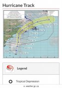
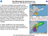
Lee is now tracking west and may make landfall in Maine or NB, and western NS where I am on the bay.

Canadian Severe weather alert:
“The trend in computer model guidance has been a somewhat faster approach speed (as it passes Cape Cod) and sooner arrival time in the region as well as a farther-west trend in the track likelihood. NOTE: A faster approach speed would increase the wind threat over western Nova Scotia and southern New Brunswick than a slower-moving storm. As of now, western Nova Scotia has the highest possibility of impacts which is worth noting since that region wasn't impacted as severely as other parts of the region during recent storms like Dorian and Fiona.”
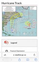
AC4B4577-52C1-452F-91B3-A2D1956AD6AA.jpeg

Baking and preparing helps with the anxiety for me. I’m making cinnamon and almond rolls with nuts, oatmeal bars, preparing vegetables for sandwiches, and making beef soup that I’ll can and freeze in small batches.
 
Tropical Tidbits latest Hurricane Lee video. The Gulf of Maine for sure, just a matter of which specific area will get the eyewall.

Hurricane LEE
As of 12:00 UTC Sep 13, 2023:

Location: 26.0°N 67.1°W
Maximum Winds: 100 kt Gusts: N/A
Minimum Central Pressure: 948 mb
Environmental Pressure: N/A
Radius of Circulation: N/A
Radius of Maximum wind: 20 nm
64 kt Wind Radii by Quadrant:

 
Last edited:
Lee is expected to make landfall here in NS on Saturday. He’s going right through the Bay of Fundy where I live on the coast over the North Mountain. It looks like a category 1 and he’s getting weaker.

The Bay of Fundy has the highest tides in the world and is famous for its marine life, including sharks! Lee may be hitting us at the same time as high tide, so the storm surge is concerning for some areas (not my home.) The wind damage, power outages and the mountain roads being cut off will be our main concern, but a kilometre down the road are beautiful homes perched by the pier that may have issues.
04E9D907-5023-4550-B500-4C39DF41229D.jpeg


I hope everyone does well!
 
Lee is expected to make landfall here in NS on Saturday. He’s going right through the Bay of Fundy where I live on the coast over the North Mountain. It looks like a category 1 and he’s getting weaker.

The Bay of Fundy has the highest tides in the world and is famous for its marine life, including sharks! Lee may be hitting us at the same time as high tide, so the storm surge is concerning for some areas (not my home.) The wind damage, power outages and the mountain roads being cut off will be our main concern, but a kilometre down the road are beautiful homes perched by the pier that may have issues.
View attachment 447124


I hope everyone does well!
Oh my! Stay safe @Lexiintoronto !! Several years back I visited N.S. and remember going to the Bay of Fundy. My husband and I drove all over N.S.
I was really interested in Lunenburg (my mothers side of the family immigrated there in the 1700's. You live in a beautiful area of Canada!
Keep us updated....
 
He’s going to be in Yarmouth where Lee is expected to make landfall and then he’s working himself up along the bay—which I guess means he’s literally going on my street past my home. There’s only one shore road here along this section of our coast, the next road that is parallel is over a mountain. I hope he doesn’t get stuck because with the high tides and a storm surge some of the road may be flooded. I really don’t understand how he’s going to stay safe. Imagine being in a vehicle during a hurricane? In a foreign country?


Lots of tropical storm warnings in New England, but I think it's mostly going to be a wind and bad seas event over there.

My niece in Plymouth MA doesn't seem to be concerned at all. She thinks the weather people are over blowing the entire thing and have no plans to evacuate.

Maybe they don't get concerned because they deal with nor'easters a lot in winter? Flooding is a different animal all together.
 
My niece in Plymouth MA doesn't seem to be concerned at all. She thinks the weather people are over blowing the entire thing and have no plans to evacuate.

Maybe they don't get concerned because they deal with nor'easters a lot in winter? Flooding is a different animal all together.
I can't agree more. Storm Surge is always the element of a Hurricane/TS that is underestimated.

Storm surge can come in very quickly, as much as several feet in 15 minutes.

Thoughts and Prayers for all in Lee's path.

JMO


Post-tropical storm Lee thrashes Maritimes, leaving power outages, coastal damage​


000
WTNT63 KNHC 162010
TCUAT3

Post-Tropical Cyclone Lee Tropical Cyclone Update
NWS National Hurricane Center Miami FL AL132023
410 PM AST Sat Sep 16 2023

...LEE MAKES LANDFALL IN FAR WESTERN NOVA SCOTIA...

Visible satellite imagery and surface observations indicate that
Post-Tropical Cyclone Lee made landfall on Long Island in Nova
Scotia around 400 PM AST (2000 UTC) with maximum sustained winds
estimated to be 70 mph (110 km/h).

SUMMARY OF 400 PM AST...2000 UTC...INFORMATION
----------------------------------------------
LOCATION...44.3N 66.3W
ABOUT 50 MI...80 KM ESE OF EASTPORT MAINE
ABOUT 135 MI...215 KM W OF HALIFAX NOVA SCOTIA
MAXIMUM SUSTAINED WINDS...70 MPH...110 KM/H
PRESENT MOVEMENT...N OR 360 DEGREES AT 22 MPH...35 KM/H
MINIMUM CENTRAL PRESSURE...968 MB...28.58 INCHES

$$
Forecaster Mahoney/Hogsett/Cangialosi/Bucci
13L_geps_latest.png


_____
ETA: I don't know if the storm will still generate energy from water because I don't understand the geography very well. (Looks like they're lots of water!)
Some storms will keep generating energy while they're near water, but other storms, will quickly dissipate. (Texas coast for example)

Since Lee will be moving NE, I assume it won't dissipate quickly. I assume, it will move quickly into the Atlantic, but how much damage will happen before it moves offshore again is beyond my comprehension.
 
Last edited:
This why they have all those warnings and tell people to stay home. From New Hampshire.
There's alot of variation along with NE Coast. There are dangerous pockets and not as dangerous pockets etc. Not only is there geographical variation, there is variation within the storm itself. It's not a true hurricane, but a storm with varying pockets of wind.

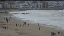
A big wave could kill people here. Post-Tropical Cyclone Lee moving north; New Hampshire seeing rough surf, some strong wind gusts

Waves crash ashore in Hampton Beach during high tide as Lee moves north in Gulf of Maine​

1694896501260.png
 

000
WTNT63 KNHC 162010
TCUAT3

Post-Tropical Cyclone Lee Tropical Cyclone Update
NWS National Hurricane Center Miami FL AL132023
410 PM AST Sat Sep 16 2023

...LEE MAKES LANDFALL IN FAR WESTERN NOVA SCOTIA...

Visible satellite imagery and surface observations indicate that
Post-Tropical Cyclone Lee made landfall on Long Island in Nova
Scotia around 400 PM AST (2000 UTC) with maximum sustained winds
estimated to be 70 mph (110 km/h).

SUMMARY OF 400 PM AST...2000 UTC...INFORMATION
----------------------------------------------
LOCATION...44.3N 66.3W
ABOUT 50 MI...80 KM ESE OF EASTPORT MAINE
ABOUT 135 MI...215 KM W OF HALIFAX NOVA SCOTIA
MAXIMUM SUSTAINED WINDS...70 MPH...110 KM/H
PRESENT MOVEMENT...N OR 360 DEGREES AT 22 MPH...35 KM/H
MINIMUM CENTRAL PRESSURE...968 MB...28.58 INCHES

$$
Forecaster Mahoney/Hogsett/Cangialosi/Bucci
13L_geps_latest.png


_____
ETA: I don't know if the storm will still generate energy from water because I don't understand the geography very well. (Looks like they're lots of water!)
Some storms will keep generating energy while they're near water, but other storms, will quickly dissipate. (Texas coast for example)

Since Lee will be moving NE, I assume it won't dissipate quickly. I assume, it will move quickly into the Atlantic, but how much damage will happen before it moves offshore again is beyond my comprehension.
The remnants of Lee will have it heading our way in the uk caught up in the jet stream , with an unsettled or even autumnal outlook next week.
 
My niece in Plymouth MA said it was breezy but otherwise nothing to speak of.

My cousin in Kennebunk ME said the breeze was nice, it was sunny and pleasant out.

Hope our friends to the north fair well without flooding and wind damage!
 
My cousin on Mt Desert Island ME didn’t lose power, but other parts of the island did. The wind and rain have calmed down. She sent this link to a map in The Quietside Journal.

https://substack.com/redirect/e8c5c...Q.eU8qSXWLsKFkey3DxSQr5Lrz26m9Dn9abzoEcw2zI0E

MOUNT DESERT, Sept. 16, 2023 - The vulnerable grid on the Quietside was exposed to Hurricane Lee today as Versant Power reported 2,026 homes without power in its live outage map.

Tremont, Seal Cove, Pretty Marsh and Northeast Harbor sustained the highest number of outages - 1,915. Bar Harbor reported 111 as of this writing. Tremont had 698 outages and Northeast Harbor had 509.

Darker areas show more than 500 homes without power, and lighter brown is between 110 and 500.
Versant reported 36,000 homes without power out of 166,000 customers served.

CMP reported 53,142 homes without power out of 671,087 customers served.

The number is bound to increase as the storm rages through Saturday night.
 
Last edited:

Members online

Online statistics

Members online
58
Guests online
3,419
Total visitors
3,477

Forum statistics

Threads
592,490
Messages
17,969,809
Members
228,789
Latest member
Soccergirl500
Back
Top