]
I didn't use a 5-6 mile range. LE has been very specific that they confined their search within a 2.5 mile radius area. Basically, I identified the three bridges, then theorized that the S. Arkansas Bridge would have been approached by her when she was riding away from the house (beginning her ride), while the Fooses Creek road bridge could be either coming or going, and the Fooses Dam bridge could only be when she was on her way home from her ride. So if she did this every Sunday morning, and it was a serious ride, what path did she take? The true trailhead of the Colorado Trail is a turn off of CR 225 which leads into the power line cut. It is 8850 ft elevation at the trails head. The trail heads up the power line cut. There is a popular worn footpath from what is mapped as the lower Colorado Trail that crosses the dam and joins the true Colorado Trail. The trail is clearly traceable all the way to the Monarch Ridge Trail at 11,400 ft, just before it joins the Loop Trail that originates at the viewing at the US 50 summit (Top of Monarch). The bicycle descent trail to Fooses Dam begins at 11,385 ft and drops rapidly to the bridge at 9,100 ft.
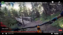
The link takes you to a very quick descent of the trail, ending on the flat wooded area up from Fooses Lake. A still shot from that video is added below, showing exactly what it looks like to first see Fooses Dam Bridge at high speed on a mountain bike. It's possible that someone blocked the bridge, and she veered right of the structure and toward a small boulder field remnant of a creek back there, losing control of the bike and being at the mercy of whoever did this. Or, it could be all my imagination, or any other scenario in between. IMO
MTB Salida - The Mponarch Crest Ride You Should Have Done - Bing video