Australia Claremont Serial Killer, 1996 - 1997, Perth, Western Australia - #6

DNA Solves
DNA Solves
DNA Solves
Status
Not open for further replies.
Please continue to discuss the CSK case here.

Remember to post according to The Rules which are found here. In general, post respectfully and don't be a jerk. If you have any questions or concerns, please use the Alert feature (little red triangle found at the bottom left of each post) to have us review if you feel something is offensive, or you can send a private message to Mods/Admin, or email to websleuthscomments@gmail.com.

:wave:

:welcome: to our new members. Glad you are here to discuss the case.
 
Can anyone answer me the following please;

- Why is the co-ordinates of the resting place of the victims of such importance?
- Has this ever helped solve other similar crimes?
 
Can anyone answer me the following please;

- Why is the co-ordinates of the resting place of the victims of such importance?
- Has this ever helped solve other similar crimes?

Body dump sites can be a factor in geographic profiling. Kim Rossmo teaches geo profiling at Texas State University and one of his books has stats on encounter sites in relation to body dump sites. Although the specific crimes are not documented, the % stats show that body dump sites have been relevant in many cases:

Scroll down to pg 173 "Locations"
https://books.google.ca/books?id=YQ...onepage&q=geographic profiling rossmo&f=false


Kim Rossmo's wiki bio:
https://en.wikipedia.org/wiki/Kim_Rossmo
 
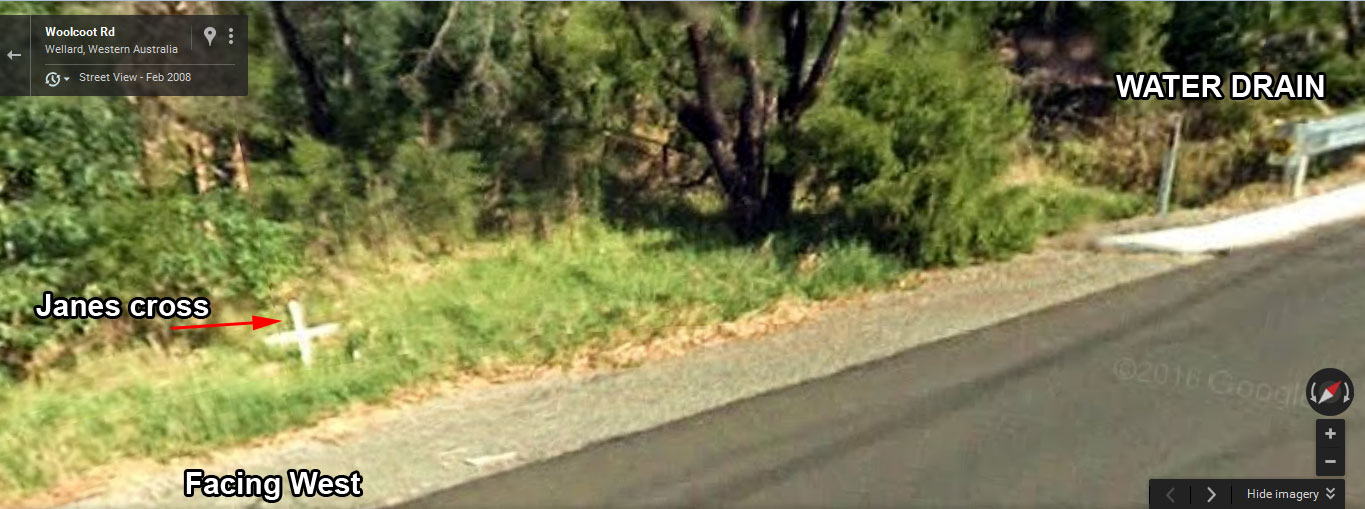
Janes road side cross

pFCv2iu.jpg


https://www.google.com.au/maps/@-32.272222,115.8591631,17z?hl=en
 
Can anyone answer me the following please;

- Why is the co-ordinates of the resting place of the victims of such importance?
- Has this ever helped solve other similar crimes?

sillybilly said:
Body dump sites can be a factor in geographic profiling. Kim Rossmo teaches geo profiling at Texas State University and one of his books has stats on encounter sites in relation to body dump sites. Although the specific crimes are not documented, the % stats show that body dump sites have been relevant in many cases:

Scroll down to pg 173 "Locations"
https://books.google.ca/books?id=YQl...tes"&f=false

Kim Rossmo's wiki bio:
https://en.wikipedia.org/wiki/Kim_Rossmo
I think we're talking about two different things here.

There's location of dump sites that Geo-profiling might be able to suggest likely areas where the killer lives and there's patterns the killer may have used.

sillybilly has covered off geo-profiling but this case is different to most in that the dump sites form a pattern;

The two girls who have been recovered were dumped on the opposite sides of the city some 80km away. If you draw a line between the two, that line goes right through the hotel/pub that the girls were last seen in.

Will this help solve the crime? Probably not. Geo-profiling would be more helpful. But it's curious how the bodies ended up in those locations, and if by design, why did the CSK do this? Then there's also the question of whether the still missing victim was dumped either on this line or at a specific angle.
 
I just read the geo profiling links. Thanks of that very interesting.

Interesting data about distance. You wouldnt think someone would drive greater than 30 kilometres either way without thinking about where they were going without researching body site first. Thanks a long way driving around with a body in the car in he the middle of the night without a thought out destination.

The two known sites are not far from gazetted roads but they are a hell of a drive, Ciara, possibly 2 hours drive up and back to Claremont in the day. Could Sarah be not far off a gazetted road? Similar distances?
 
- It's all but certain the CSK researched the sites prior.
- I think it's only about 35 minutes to Wellard and 45 minutes to Eglington. So 70 and 90 min round trips travel wise. I don't think he would have spent long at the dump site. Dump and get out of there asap.
- I'd be thinking it might be worth having a look at places on the "CSK Line" where roads intersect. The first place I'd look is on that line further out than the JR site.
- I think it's likely it's not a coincidence that the 2 girls are dumped 180 degrees from each other from the Conti. But did he decide this before the murders? Or did he decide just when he dumped CG?
- If he decided prior, then that's a lot of planning and I would suggest fantacising
 
- It's all but certain the CSK researched the sites prior.- I think it's only about 35 minutes to Wellard and 45 minutes to Eglington. So 70 and 90 min round trips travel wise. I don't think he would have spent long at the dump site. Dump and get out of there asap. - I'd be thinking it might be worth having a look at places on the "CSK Line" where roads intersect. The first place I'd look is on that line further out than the JR site.- I think it's likely it's not a coincidence that the 2 girls are dumped 180 degrees from each other from the Conti. But did he decide this before the murders? Or did he decide just when he dumped CG?- If he decided prior, then that's a lot of planning and I would suggest fantacising
Perhaps it is just to do with the way Perth is laid out? It runs along the coast north to south. The CSK might just have decided to drive south for one as far as practical (given timeframes) and then just gone north for the other?It's pretty easy to just get onto the Freeway North or South from Claremont and that would then take you quickly out of the city and on to the areas chosen.
 
In the day, the freeway was very different. To get to Eglinton you would have to venture onto Wanneroo at much earlier point than todays free run of the night you might achieve.

Probably why the bricklayer was leaving at such a time in the morning that spotted the Ford Falcon station wagon on Pippidinny road.

The taxi had its headlights off as it turned off Pipidinny Rd, Eglinton, on to Wanneroo Rd in the pre-dawn darkness, the Two Rocks resident told The Sunday Times. He said he had to hit his brakes to avoid hitting it.
http://www.perthnow.com.au/news/west...956cdffd1aa3ab

4.30 in the morning in pre dawn darkness. Thats mmm what time did she go missing? Midnight? Thats 4 and half hours at the exit point of Pippidinny.A

The furtherest northern freeway off ramp point in 1996 was Ocean Reef exit?
 
If a taxi had gone Pippidinny rd at that time of the morning, one of the residents would have known who called it, because there may have only been a dozen houses in the Eastern end the street.

Police could have cleared who may have arrived home or departed in a cab at 4.30 in the morning in Pippidinny road. Being dirty as all hell this taxi may have taken dirt roads from Burns beach road or similar on the semi hard bush ground. Being dirty, it may have bogged along the way, or climbing back up to Pippidinny road off the loop track that exists.

Here you can see an officer coming up the hill from Ciaras position.

b8888151z.1_20160125224142_000_gahefifg.4_1-1bacdda.jpg

https://au.news.yahoo.com/thewest/wa...-third-family/
ciara_2002.jpg
 
Perhaps it is just to do with the way Perth is laid out? It runs along the coast north to south. The CSK might just have decided to drive south for one as far as practical (given timeframes) and then just gone north for the other?It's pretty easy to just get onto the Freeway North or South from Claremont and that would then take you quickly out of the city and on to the areas chosen.

I'd speculate he chose north and south because these would be familiar routes out of the city for anyone living in the Claremont surrounds. South is Rockingham, Mandurah and the Yallingup/Margaret River region. North is Lancelin, Yanchep etc. All seaside holiday spots.

I'd also speculate he chose the distance out of the city as a function of night time hours available, chance of getting pulled over, and remoteness - which he rationalised the edge of the city. Close enough to drop the body under darkness, not too far as the longer he drives with a body in the car the increased chance of being pulled over, and sufficiently remote for the body not to be discovered immediately.

But there's a lot of places he could dump the body north and south and satisfy whatever criteria he had. Somehow they ended up exactly 180 degree from each other. Could be coincidental but that's a hell of a coincidence.
 
In the day, the freeway was very different. To get to Eglinton you would have to venture onto Wanneroo at much earlier point than todays free run of the night you might achieve.

Probably why the bricklayer was leaving at such a time in the morning that spotted the Ford Falcon station wagon on Pippidinny road.

The taxi had its headlights off as it turned off Pipidinny Rd, Eglinton, on to Wanneroo Rd in the pre-dawn darkness, the Two Rocks resident told The Sunday Times. He said he had to hit his brakes to avoid hitting it.
http://www.perthnow.com.au/news/west...956cdffd1aa3ab

4.30 in the morning in pre dawn darkness. Thats mmm what time did she go missing? Midnight? Thats 4 and half hours at the exit point of Pippidinny.A

The furtherest northern freeway off ramp point in 1996 was Ocean Reef exit?
Pretty sure he said he saw the taxi on a Sunday morning 4:30am. She went missing on Friday night at midnight. 28 and one half hours.
 
That would mean that Ciara was kept overnight, then taken away next day.

I think they drove up Stirling highway and headed north or south to the respective positions via Freeway on ramp in the city which lead them in the corresponding directions north south with no traffic lights for some way. With a taxi driving through the city would essentially bury them in hundreds of other taxis, leaving everyone none the wiser.

Even coast road for that matter. They hit the roads and head up or down. Or they run the victims to the nearest yacht club, put them on a sail boat and sailed up and down the coast totally away from anyone held without scrutiny. Then when the heat died, they would put the body in a car and take the bodies from the nearest anchor point to the prospective sites.

Police said some were killed in short time, they didn't say they were dumped in short time. Bodies were discovered some time later. Both sites are coastal.

I think both points were not far from the prospective freeway points of planning.
 
I'd speculate he chose north and south because these would be familiar routes out of the city for anyone living in the Claremont surrounds. South is Rockingham, Mandurah and the Yallingup/Margaret River region. North is Lancelin, Yanchep etc. All seaside holiday spots.

I'd also speculate he chose the distance out of the city as a function of night time hours available, chance of getting pulled over, and remoteness - which he rationalised the edge of the city. Close enough to drop the body under darkness, not too far as the longer he drives with a body in the car the increased chance of being pulled over, and sufficiently remote for the body not to be discovered immediately.

But there's a lot of places he could dump the body north and south and satisfy whatever criteria he had. Somehow they ended up exactly 180 degree from each other. Could be coincidental but that's a hell of a coincidence.

How exact are we talking in terms of 180degrees? Are we talking to the nearest metre? Or within a few km?
 
Maybe some wealthy individual had a fetish for catholic virgins? How long had the boat been in the Swan? It is sunk direct west of Janes body, 13.5 kilometres

In July 2007, the 34.14 metre timber cabin cruiser W. Saville-Kent sunk in Mangles Bay, near Garden Island navy base

"The story was that about 10 years ago it was parked up in the Swan River, off East Fremantle, and used as a brothel," he said.

http://www.watoday.com.au/wa-news/brothel-boat-to-float-again-20090402-9kji.html
 

Looking at that, it looks like the killer might just have taken the most convenient routes to get away from Claremont to a secluded spot. The fact that one goes north and another south probably means he followed the freeway in Perth which goes only two directions (you guessed it, north and south).

Going East means having to go through the city most likely or back through Fremantle. A lot of messing around.
 
How exact are we talking in terms of 180degrees? Are we talking to the nearest metre? Or within a few km?
Metre.

From the exact spot from where JR was dump to the exact spot CG was dumped - that line goes right over the top of The Conti.

Could be a coincidence.
He may have dumped JR and then when deciding where to dump CG he chose to play a game and go 180 degrees.
The CSK may have pre-planned it before the killings.

There's a lot of places to dump the bodies north and south so to choose spots that are on a straight line through the Conti is a massive coincidence.
 
Status
Not open for further replies.

Members online

Online statistics

Members online
261
Guests online
681
Total visitors
942

Forum statistics

Threads
611,135
Messages
18,277,318
Members
235,310
Latest member
kiagee
Back
Top