I made a map too.
Part of the problem is that there are [at least] TWO trails known as Hite Cove/Hites Cove. The one that
@jonjon747 marked on his map is not where they were.
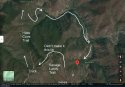
Here you can see in the upper left the trailhead of the wrong Hite Cove trail, starting at Highway 140. But that's not where they were -- the red rectangle shows the area where they were actually hiking.
View attachment 312593
Now zooming in to that red rectangle area, you can see where they were.
View attachment 312594
Blue dot = where truck parked.
Yellow line = first leg, down (the other) Hites Cove trail
Green line = trail along the SF Merced River. This might be called part of Hites Cove trail as well, I'm not sure.
Red line = Savage-Lundy trail, they were hiking back up.
Black dot = roughly where they were found.
MOO