Found Deceased Spain - Esther Dingley, from UK, missing in the Pyrenees, November 2020 #5

Status
Not open for further replies.
An underfeed person tires more easily and has more problems with staying warm (you need these nutrients to keep your core temperature up, it is a fuel for your body). And being cold, hungry and exhausted while on the trail fuzzies your mind and makes easier to make that one bad decision, one stupid mistake or one wrong step leading to tragedy. So, when a hiker goes missing it is important what they ate, because it might have been one of the circumstances diminishing (or increasing) their chance to survival. I do not want blame Esther for her demise, it is important though to see all the circumstances that might lead to an unfortunate accident.

Exactly this. You can obviously live a long time without food, all things being equal.

But you cannot live long if you are exposed to wet and wind and low temps. This is also where fuel becomes very important at altitude in sub zero.

It is also critical to keep moving if you can't find some shelter. My dad is fond of recounting the time he walked out of the NZ high country from a shooting expedition when a bad storm grounded their helicopter.

The storm was so bad he had to drag the dog out of the hut and carry it for a few 100m to stop it going back.

But the point was, so long as he kept moving, he could keep his core temperature up.

The risk is, if you get injured on your own, and can't keep moving, walking out light, you are in huge huge trouble.
 
Des ossements retrouvés dans les Pyrénées, peut être ceux d'une randonneuse


Ester Dingley, a 37-year-old English hiker, disappeared last autumn.

A few days ago, hikers found human remains that could be hers, near Bagnères, according to a source close to the investigation. It is a piece of human skull "with remains of hair," discovered "near a hiking trail at Port de la Gléré," where there were also bones found "of animal origin."

A DNA expertise has been entrusted to the forensic laboratory in Toulouse, which will have to determine whether it is indeed the British woman. The presence of human and animal bones suggests that they could have been brought there by an animal, as the area had been thoroughly combed by the gendarmes.


BBM


The Port de la Glère was probably the gateway for her to return to Spain. A "Port" in the Pyrenees is a passage. She may have wanted to go that way when she saw the path from the Port du Vénasque... She may have crossed by the ridges, it's difficult to say, or she may have taken the wrong path.

SBM.

Thanks for this. Interesting that a local, and experienced in SAR, does think it possible that she may have decided to change route and try to head west along the ridge in order to go the clockwise route, instead of down to the Refuge de Venasque and then anti-clockwise.

I'd imagine those initial early searches before the weather deteriorated were concentrated on the route down to the refuge, I wonder how long it was before the ridge and Port de la Glere area were searched?
 
True, there is no route from Pic de Sauvegarde to Port de la Glere. Esther would have either camped open, or stayed in the refuge she stayed at the previous nights, prior to hiking from a location in Spain to Port de la Glere. She had to return to the trailhead to hike the route to the Port de la Glere, or she could have hiked there via the Refuge de Venasque.

I have wondered whether she thought she could create a new trail between Pic de Sauvegarde and Port de la Glere, following animal trails (as that is mentioned in her blog) between the two points on the mountain ridges. At this point, I'm assuming that the bones belong to Esther and that she hiked to the Port de la Glere either from the trailhead or from the Refuge de Venasque. I don't believe that skull, hair and bones were put in one location by animals except if the body was originally nearby.

BBM

Yes I'm wondering now, in light of what Patrick Lagleize of the Luchon mountain office said in the above post from @ZaZara , if maybe she thought she could head along the ridge. Maybe from a distance it might look traversible. If she did I think she would soon have got into difficulty looking at some of the views on Google Maps at various points along it --> Google Maps --> Google Maps
 
SBM.

Thanks for this. Interesting that a local, and experienced in SAR, does think it possible that she may have decided to change route and try to head west along the ridge in order to go the clockwise route, instead of down to the Refuge de Venasque and then anti-clockwise.

I'd imagine those initial early searches before the weather deteriorated were concentrated on the route down to the refuge, I wonder how long it was before the ridge and Port de la Glere area were searched?

The Port de la Glere was part of her planned route, so it would have been searched on the first day, by helicopter to start with.

I find it hard to believe that Esther would have gone from the top of the Salvagurdia to the Port de la Glère after telling Dan of her plans and with so little daylight remaining. There is no path that I know of, it is one-way up and down.
IMO, not sure that Patrick Lagleize meant to say that she did take the west route instead of going to the Refuge de Venasque for the night as planned. Still, his remarks about 'the logic of their progress' are very interesting.
I do remember from an earlier hike that she posted of FB that she had trouble keeping the right track going up to another mountain top, but she got there. ;)

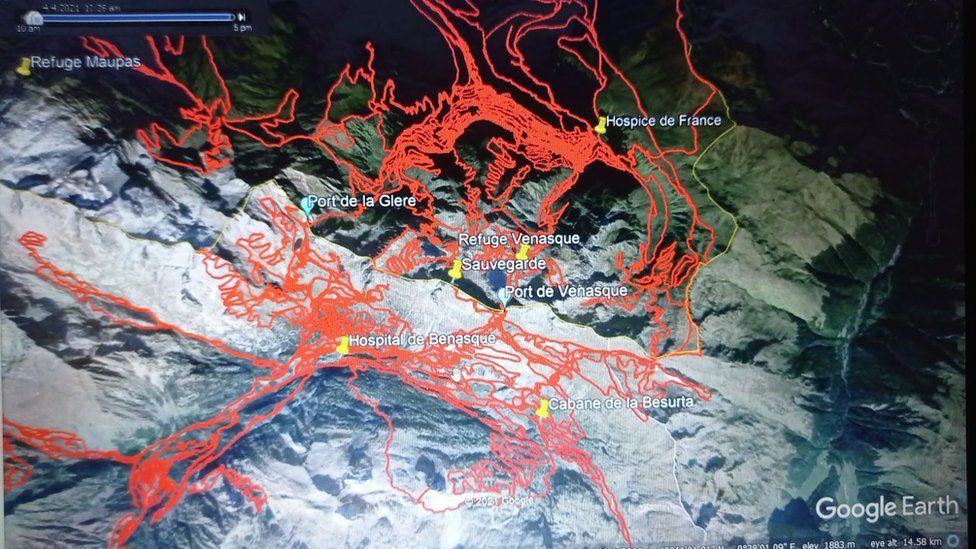
Dan apparently does not believe this west route either, since the line Sauvegarde - Port de la Glere is more or less the one track he did not hike, except for the part in the middle.
He obviously looked for Esther in the area where she may have had a good network connection but did not make a call.

_119382287_9f79a52d-7cd9-43ff-b437-fc9b6d728c75.jpg


Esther Dingley: Partner vows to keep searching for missing hiker
 
Last edited:
I find it hard to believe that Esther would have gone from the top of the Salvagurdia to the Port de la Glère after telling Dan of her plans and with so little daylight remaining.

I do too to be honest. It's a long shot, but it is a possible explanation of how/where she may have got into difficulty on what was meant to be a straightforward route, and also why the remains, if hers, were found where they were.
 
Regarding the text messages that Esther's partner shared publicly, I suspect that the content that he did not include is of a personal nature - unrelated to her route. I don't think he withheld anything relevant to her planned hike.

T

Thanks for this, Otto. I've no idea, tbh. All I can say is that confirmatory sources are essential, and it's important to take note of evidence which contradicts a single source or narrator. All narrators are unreliable to some degree, because they're human.

In many missing persons cases, it seems at the outset that family and friends are reluctant to give negative information about the missing person. And I get it—if the person is found within hours or even a day or two, loved ones don’t want s/he to have to contend with the embarrassment or whatever.

The problem with that approach is, IMO, in the beginning of a search, nobody really knows what may be relevant and pertinent. And if information is not shared in the beginning, it becomes very hard to later add not-so-great details and have them matter. When the details might have helped at the outset of the search, and might have made a difference in the outcome.

Everyone has “dirty laundry” we’d prefer the world not know. But if I went missing, and needed help, I wouldn’t care what the world found out. Save me. Please.

If the skull found is Esther, I’m not sure any more/different info would have helped, but that’s the thing. We’ll never know.
 
My thinking at the moment rests largely on whether Esther was the type to go off-piste and explore or take short-cuts. I'm convinced that if she stayed on the path, there would be no problem. People just don't fall off a path, just as they don't fall into the traffic when they walking along a roadside. It's a basic human motor skill. And even if she did somehow slip/trip/fall from the path, then she (and/or her pack) would have been found because the treacherous places are obvious.

No. I don't see it happening, and I haven't heard any evidence that weather conditions were bad enough to cause any accident on the path. On the other hand, if she had a spirited/inquisitive/spontaneous/quixotic/thrill-seeking personality and was often known to strike off the path, then that's a completely different thing.
Is there any anecdotal evidence about whether Esther might be inclined to do that?
 
Des ossements retrouvés dans les Pyrénées, peut être ceux d'une randonneuse
It is a piece of human skull "with remains of hair," discovered "near a hiking trail at Port de la Gléré,"

A piece of human skull. A piece. Not the whole thing!

Would that indicate that Esther had a serious fall and smashed her head on the way down?

Perhaps an animal like a vulture grabbed a small piece and brought that to its current location, and the rest of her remains (including clothing and rucksack) are elsewhere down in a steep rocky ravine, where SAR didn't get to.....?

MOO.
 
Last edited:
The Port de la Glere was part of her planned route, so it would have been searched on the first day, by helicopter to start with.

I find it hard to believe that Esther would have gone from the top of the Salvagurdia to the Port de la Glère after telling Dan of her plans and with so little daylight remaining. There is no path that I know of, it is one-way up and down.
IMO, not sure that Patrick Lagleize meant to say that she did take the west route instead of going to the Refuge de Venasque for the night as planned. Still, his remarks about 'the logic of their progress' are very interesting.
I do remember from an earlier hike that she posted of FB that she had trouble keeping the right track going up to another mountain top, but she got there. ;)

Dan apparently does not believe this west route either, since the line Sauvegarde - Port de la Glere is more or less the one track he did not hike, except for the part in the middle.
He obviously looked for Esther in the area where she may have had a good network connection but did not make a call.

_119382287_9f79a52d-7cd9-43ff-b437-fc9b6d728c75.jpg


Esther Dingley: Partner vows to keep searching for missing hiker
As we’ve looked at it upthread, ED’s message to DC is more likely to refer to a next leg of P de la G rather than the Refugio de V. DC decided to interpret it as “next leg after the Pic is the Refugio de V and then down to the Hospice”.

IMO she didn’t go to the Refugio de V (indeed LE found no sign that she did), but in one way or another had the P de la G as her next destination. I can’t even imagine, though, that she went cross-country, but perhaps you might do that if you didn’t have a paper map and couldn’t see the lay of the land? (A phone would have been way too small to see the layout; you need all the contours, see how the ridges go, etc. Plus , the GPS needs satellites; if it’s overcast or you’re behind a mountain, no satellite view). And then you have to conclude that she slept out there?
Since I can’t even imagine any of this, and the folly of it, my assumption is that she went to the Cabane de Besurtas for the night, as she had done the day before, and hauled up to the P de la G the next day. She would then have been at the P de la G at around 4 pm and beginning to dip into France. That’s what I’d imagine, but in this case, there’s no telling what choices ED might make.
I guess SAR, though, is saying she might have attempted a route cross country to the P de la G? Ay.
 
I do too to be honest. It's a long shot, but it is a possible explanation of how/where she may have got into difficulty on what was meant to be a straightforward route, and also why the remains, if hers, were found where they were.

IMO when applying logic, you should leave the 'what would Esther do' out of the equation.

The central question would be 'where can someone slip, fall and not be found?' and as Dan has explored, that would be nowhere on the route that Esther was supposed to have taken.

So, instead, look for places where someone might slip and fall.
Spanish SAR thought of the surroundings of the Salvaguardia, the last known location, for a reason.
Patrick Lagleize apparently takes this one step further by suggesting the ridges.

The only way to find out who is 'right' is to test the hypothesis and search the area between the Port de Venasque and the Port de la Glère. Only problem that I can see is that very few people hike there. But SAR may follow where the birds go from afar.

Perhaps Esther did indeed do something no one ever thought she would do. I still don't think it is likely, but there is logic in it.
 
A piece of human skull. A piece. Not the whole thing!

Would that indicate that Esther had a serious fall and smashed her head on the way down?

Perhaps an animal like a vulture grabbed a small piece and brought that to its current location, and the rest of her remains (including clothing and rucksack) are elsewhere down in a steep rocky ravine, where SAR didn't get to.....?

MOO.
The piece of skull on the scree below la Glere was definitely a vulture's work. Absolutely no doubt about it. No other theory comes close. The authorities should know that perfectly well but are probably downplaying the vulture thing out of delicacy.

And from that we can safely conclude that Esther did not necessarily meet her fate anywhere near that spot.
 
As we’ve looked at it upthread, ED’s message to DC is more likely to refer to a next leg of P de la G rather than the Refugio de V. DC decided to interpret it as “next leg after the Pic is the Refugio de V and then down to the Hospice”.

IMO she didn’t go to the Refugio de V (indeed LE found no sign that she did), but in one way or another had the P de la G as her next destination. I can’t even imagine, though, that she went cross-country, but perhaps you might do that if you didn’t have a paper map and couldn’t see the lay of the land? (A phone would have been way too small to see the layout; you need all the contours, see how the ridges go, etc. Plus , the GPS needs satellites; if it’s overcast or you’re behind a mountain, no satellite view). And then you have to conclude that she slept out there?
Since I can’t even imagine any of this, and the folly of it, my assumption is that she went to the Cabane de Besurtas for the night, as she had done the day before, and hauled up to the P de la G the next day. She would then have been at the P de la G at around 4 pm and beginning to dip into France. That’s what I’d imagine, but in this case, there’s no telling what choices ED might make.
I guess SAR, though, is saying she might have attempted a route cross country to the P de la G? Ay.
I've inspected Sauvegarde on Google Earth from every angle and conclude there is really no feasible route between the pic and P de la G along the ridge. The western shoulder of Sauvegarde has impassible looking crags that will involve more than a scramble.

The only route to P de la G is back down to the road and back up again but I really doubt she would even do that. To go back down to the road and climb up the same side of the valley again would be... well... kind of repetitive, and she wouldn't go to P de la G unless she intended to continue all the way round clockwise through France. But - here's the killer logic - if she was really determined to do the Imperatrice loop she would do it anti-clockwise from P de Vanesque because she was already there.

So I don't believe she went to P de la G at all. She'd already climbed up Sauvegarde twice on consecutive days (which is bizarre enough) and she would surely have had enough of that flank of the mountain.
 
Last edited:
People just don't fall off a path, just as they don't fall into the traffic when they walking along a roadside.

And even if she did somehow slip/trip/fall from the path, then she (and/or her pack) would have been found because the treacherous places are obvious.

But you have to look at the route. On passing over the mountains from Spain to France, you potentially go from light, bright almost summer conditions to the shade side of the mountain which is in shadow and potentially icy. You only have to look at the trail down into france from port de la Glere, it's very steep (trail zigzags) and on a shale covered steep slope, with a cliff below. She might not have even realised she was in trouble until she was sliding. On a normal summer's day- no problem, easy trail. Winter, problem. And don't forget DC thought she was going the other way round (anti-clockwise), this area comes into play if she travelled clockwise and therefore they wouldn't necessarily have been looking at this as a problem area in the initial search.
 
The only route to P de la G is back down to the road and back up again (...)

Not exactly. There is another path linking refuge de Vénasque (east of the map) and Port de la Glère (west). It goes over a pass south of Pic de Sajus, then along a lake (Lac de la Montagnette), then downhill inside cirque de la Glère where it meets the much more trampled classical path from the Pique valley (the road downhill).

This is obviously a harder path than the detour through Hospice de France, but it is nonetheless plain hiking, not alpinism. It is traced on Openstreet map, hence is not a secret (though it is not waymarked). If she slept Saturday evening at Refuge de Vénasque (very likely for me) and chose this road, it might help to explain why there was absolutely no phone contact on Sunday : unlike the descent to Hospice de France, these secondary valleys are unlikely to have mobile phone access.

Capture d’écran de 2021-07-28 18-29-05.png
 
Not exactly. There is another path linking refuge de Vénasque (east of the map) and Port de la Glère (west). It goes over a pass south of Pic de Sajus, then along a lake (Lac de la Montagnette), then downhill inside cirque de la Glère where it meets the much more trampled classical path from the Pique valley (the road downhill).

This is obviously a harder path than the detour through Hospice de France, but it is nonetheless plain hiking, not alpinism. It is traced on Openstreet map, hence is not a secret (though it is not waymarked). If she slept Saturday evening at Refuge de Vénasque (very likely for me) and chose this road, it might help to explain why there was absolutely no phone contact on Sunday : unlike the descent to Hospice de France, these secondary valleys are unlikely to have mobile phone access.

View attachment 306294


Welcome to WS, @Pyrenean passer-by, and oops... that is an interesting post to say the least.

From the description of that trail via the link that you posted:


This hike is recommended in summer, to avoid persistent snow that could make it more hazardous.

It is rated very difficult for two reasons. Firstly, because of the difference in altitude which is very important, and even brutal in descent between the Col de La Montagnette and the Cirque de la Glère. On the other hand, because an important part of the circuit is not marked out and requires a good knowledge of the high mountain. The time frame is a bit long because the difficulty of the circuit requires frequent stops to rest the calves.

Very good shoes that hold the ankles well are essential because of the walking on scree and rocky chaos.
Hiking poles are also highly recommended.

For those who would like to avoid the part between the Port de Vénasque and the Col de La Montagnette, there is the possibility to go back down to the refuge de Vénasque, to pass on the spit of land that separates the Boum Supérieur from the Boum du Milieu and to follow the well marked path that leads to the pass. Longer but more accessible.

Finally, the route between the Port de Vénasque and the Col de La Montagnette can vary from one year to the next and there are many cairns which multiply the possibilities and do not necessarily make the task easy.


BBM

I wonder how well Esther could read the translation of this description. It has many pithy cautions in it:

"Very good shoes that hold the ankles well are essential because of the walking on scree and rocky chaos. Hiking poles are also highly recommended."

I would think this description would be apt for many of the trails on that eastern (French) side of the divide, including the upper part of any of the Ports.

Finding her hiking poles would sure be helpful in determining her route

Even without snow scree and rocky chaos are dangerous

I think Chief Cartographer Otto has posted the terrain maps for this area in prior pages.
 
. If she slept Saturday evening at Refuge de Vénasque (very likely for me) and chose this road, it might help to explain why there was absolutely no phone contact on Sunday : unlike the descent to Hospice de France, these secondary valleys are unlikely to have mobile phone access.

View attachment 306294

SBM BBM

Yes, this route makes total sense to me and explains why there was not only no phone contact, but also no signal from her phone after 4pm on 22nd. I cannot imagine that ED would not have turned on her phone at some point the next day if she had gone to Port de la Glere via the Spanish side. It also explains the lack of FB posts on the 22nd (when she had been posting every day in the days leading up to that day).
 
The Port de la Glere was part of her planned route, so it would have been searched on the first day, by helicopter to start with.

I find it hard to believe that Esther would have gone from the top of the Salvagurdia to the Port de la Glère after telling Dan of her plans and with so little daylight remaining. There is no path that I know of, it is one-way up and down.
IMO, not sure that Patrick Lagleize meant to say that she did take the west route instead of going to the Refuge de Venasque for the night as planned. Still, his remarks about 'the logic of their progress' are very interesting.
I do remember from an earlier hike that she posted of FB that she had trouble keeping the right track going up to another mountain top, but she got there. ;)

Dan apparently does not believe this west route either, since the line Sauvegarde - Port de la Glere is more or less the one track he did not hike, except for the part in the middle.
He obviously looked for Esther in the area where she may have had a good network connection but did not make a call.

_119382287_9f79a52d-7cd9-43ff-b437-fc9b6d728c75.jpg


Esther Dingley: Partner vows to keep searching for missing hiker

When I look at that map, and know that within days of her disappearance Dan was leaning towards criminal event, I wonder whether he is looking for bones, or demonstrating that he has hiked far and wide and did not see her - therefore she was abducted.
 
SBM BBM

Yes, this route makes total sense to me and explains why there was not only no phone contact, but also no signal from her phone after 4pm on 22nd. I cannot imagine that ED would not have turned on her phone at some point the next day if she had gone to Port de la Glere via the Spanish side. It also explains the lack of FB posts on the 22nd (when she had been posting every day in the days leading up to that day).

It looks to me like Dan's track shows him not only traversing this lesser route described by @Pyrenean passer-by : the col of the Pic de La Mongnaette, just south west of the Lac de la Mongnanette, but also directly along the spine of the unnamed ridge just to the west of it. It's just to the west of the yellow Sauvegarde pin on his map.
_119382287_9f79a52d-7cd9-43ff-b437-fc9b6d728c75.jpg


This is also a ridge over where the apparent skull fragment is found.

I don't see his tracks in col just south-east of the Port de la Glere, likely because it is so steep and scree-filled. No path appears on the terrain maps in that area.
 
Last edited:
Status
Not open for further replies.

Staff online

Members online

Online statistics

Members online
227
Guests online
2,333
Total visitors
2,560

Forum statistics

Threads
592,666
Messages
17,972,724
Members
228,855
Latest member
Shaunie
Back
Top