Shiressleuth
Former Member
- Joined
- Nov 25, 2016
- Messages
- 10,088
- Reaction score
- 4,832
Lost my reply again, sent to Truth so will get back shortly.

Exactly. If I guess it was 1 to 2 weeks after the bin was picked up that the Police went to the recycling centre then logic dictates it had long gone. So why did the family give the Police so much heat over this and confuse things with talk of landfill?
 http://uploads.tapatalk-cdn.com/
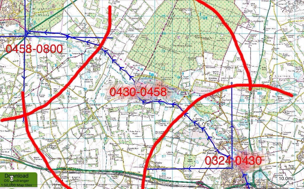
Sent from my iPad using Tapatalk[/QUOTE]
Just trying to verify sources. Top pic doesn't show high wall or hedge and he went from the parking place to So bar so don't know whether his route went near Flex when he left the car.
The phone pings 0430 and 0458 give us 28 minutes. Assuming that is roughly the time it took the phone to go thru the dead zone which midsummers map shows as roughly 6 miles this gives us the12 mph. Is that how that speed has been estimated?
Apologies if this has been asked previously, I do follow the threads closely but may have missed it.
Midsummer; Is there a map which shows the masts triangulation? Or are they in a line with only overlaps from two?
I just wondered if the police reference in an early website update is based on triangulation or whether it's either a) withheld evidence based or b) a guess.
https://www.suffolk.police.uk/news/missing-persons/corrie-mckeague
October 2nd update said:
"Enquiries and information received over the past week have led police to believe he may have been in the Mildenhall area at some point between 4.30am and 8am on Saturday 24 September, and police would like to hear from anyone who may have seen or spoken to a man matching Corries description in this area around this time"

Just trying to verify sources. Top pic doesn't show high wall or hedge and he went from the parking place to So bar so don't know whether his route went near Flex when he left the car.
I took the ping times from midsummers map as I thought times were only added if it was from a verified source. Correct me if wrong.
Again that's not an easy answer to give. I honestly wish I could even intimate in a positive way so that we could infer from my intimations. As has been stated earlier by James, phone mast TX/RT is not an exact science. Even woods and trees offer up some soot of masking (signal loss).
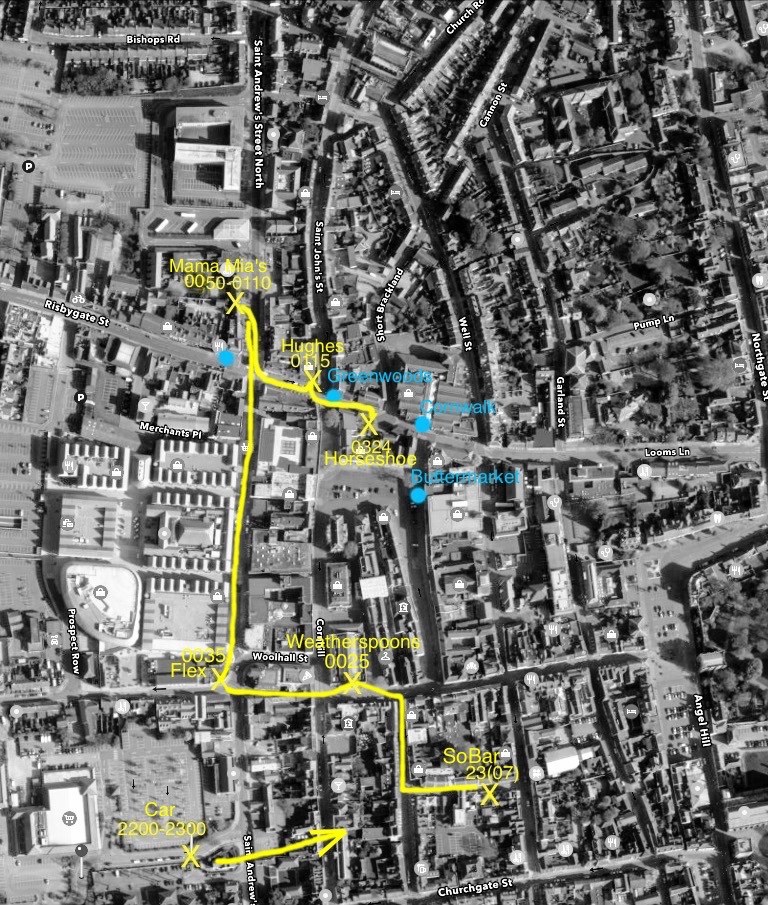
I'm basing my maps on a rough 3 mile radius of the mast. If you push a road into that mast footprint like the A1101 which we are told the bin lorry took, then even that road has black spots (signal loss). We can however presume that the phone travelled along that route towards BM as its the easiest and most straightforward regardless whether Corrie was with it or not. The phone travelled towards the mast....it's that simple.
Now the complicated part. If you radii from the BM mast an 3-5 mile line and bisect a road that heads towards the mast....that gives you the stated 0458 approximate ping location.
Extrapolate from that a t/s/d equation using a sensible 30mph and the times to all points of the rest of the radii can be worked out (see my map).
Sent from my iPad using Tapatalk
")
The term 'triangulation' is a misnomer. I believe only two masts are used to location the rough approximate location of a device. Intersecting roads with the third mast narrows it down further. Need an expert for that which I ain't. Just got slightly above average knowledge than the layman that's all.
Sent from my iPad using Tapatalk
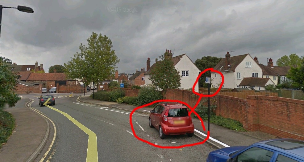
Ur right I can see a wall but not the hedge. Also I don't know whether this is exactly where he parked or not and I don't know where the cctv is either. Just asking for clarification this is the EXACT spot that's all. Is it exactly where he parked?What do you mean by doesn't show high wall? It's right there isn't it?
The hedge is on the opposite side of the road to where the cars are parked. So it's on the left of the image here and the wall is to the right of the pavement. You can see part of the hedge here on this picture and it's quite clear on Streetview.
Ur right I can see a wall but not the hedge. Also I don't know whether this is exactly where he parked or not and I don't know where the cctv is either. Just asking for clarification this is the EXACT spot that's all. Is it exactly where he parked?
Ur right I can see a wall but not the hedge. Also I don't know whether this is exactly where he parked or not and I don't know where the cctv is either. Just asking for clarification this is the EXACT spot that's all. Is it exactly where he parked?
Thanks for confirming that fact James.This leaves just the phone pings to be confirmed or not. This parking spot could end up being the only definate fact we are left with imo.It's when Nicola spoke to the students.
He parked in the Disabled Bay. The link is on the other thread.
And that's the only Disabled Bay on the road that Nicola named.
So it's "exactly" the spot.
Ur right I can see a wall but not the hedge. Also I don't know whether this is exactly where he parked or not and I don't know where the cctv is either. Just asking for clarification this is the EXACT spot that's all. Is it exactly where he parked?
Here you go, Shiressleuth:
So to be exact there are two disabled parking spaces. Corrie was parked in one of them. The hedge or bush is opposite the brick wall (see google link below) and goes nearly as high as the lampost! This is because Robert Boby Way is on a hill and the Waitrose car park is about 7-8 feet higher than road level at that point. Waitrose car park may well have CCTV but I doubt it could see Corrie's car.
The nearest CCTV that could catch Corrie walking to So Bar going by the Oct 2015 Streetview is the council camera outside Flex. If a local knows of any others that could change things. I personally feel he wasn't seen on CCTV in the car.
https://www.google.co.uk/maps/@52.2...4!1swnzJQY-4QOmpw8jm8W3nRg!2e0!7i13312!8i6656