UK UK - Corrie McKeague, 23, Bury St Edmunds, 24 September 2016 #9

Status
Not open for further replies.
Exactly. If I guess it was 1 to 2 weeks after the bin was picked up that the Police went to the recycling centre then logic dictates it had long gone. So why did the family give the Police so much heat over this and confuse things with talk of landfill?
I assume the "duty of care" is to the "potential victim" rather than the family. Hence the role of the Police Liaison Officer.
Their role is "as described on the tin". That being, keeping the family informed as to the developments in the case, rather than letting them dictate the pace and direction of an investigation.

Which is bizarre, in this situation.

I noted TW's comments in an TV interview. He was almost dictating what he believed was the issues. And it was kind of bizarre for a couple of reasons. More so "what was not said" rather than "what he did say".

He basically ruled out terrorism on logical grounds, but lumped in terrorism with AWOL.
He said that AWOL would be something that was either pre-planned so therefore would leave a trail or was on the spur of the moment, due to an instant response to a situation (say if someone "broke" for a better word). He noted that in Corrie's case, neither applied.

I like how AWOL was put together with Terrorism.

He then spoke about other possible situations. They were either that Corrie was taken forcefully or that an accident befell him and he was already dead.

Can see the pattern there !

He never mentions a "pre planned meeting, wherein Corrie went off with someone willingly....yet recklessly".

Lumping "AWOL" in with "Terrorism", places "both" as "outliers". That then gets accept as so, and forgotten.

The simple truth is....we don't know. And neither does he.
If you take the "stats" on young soldiers, "AWOL" has a much higher likelihood of happening than "Terrorism". Infact Terrorism would rank at the bottom, whereas AWOL would rank at the top.

But we'll ignore the stats and look at the situation. And here the possibility of Corrie meeting someone known to him (be that briefly or for awhile) is ignored completely. It's a "no issue".

Effectively, he presents four options. Terror (X), AWOL (X), Being Taken (?) or Accident (?). That's the menu on offer. Pick one.

I can imagine the police being directly in conflict with this approach. And possibly even "unwilling" to deal with him.
 
8a32911c165d09fdaa337ebf83cccf61.jpg
4fedd175a78a7a3f4d1f84af94e3955f.jpg
6ab8d9505abd4c03583431516ddbdcea.png
16e397fd5e81b0bf38ad17e9d8714779.jpg
3ae7c48d98c6bf5e90deb07805f057b8.jpg
http://uploads.tapatalk-cdn.com/


Sent from my iPad using Tapatalk[/QUOTE]
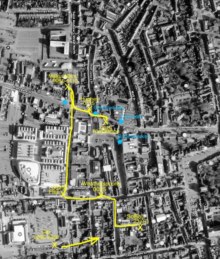
Just trying to verify sources. Top pic doesn't show high wall or hedge and he went from the parking place to So bar so don't know whether his route went near Flex when he left the car.
 
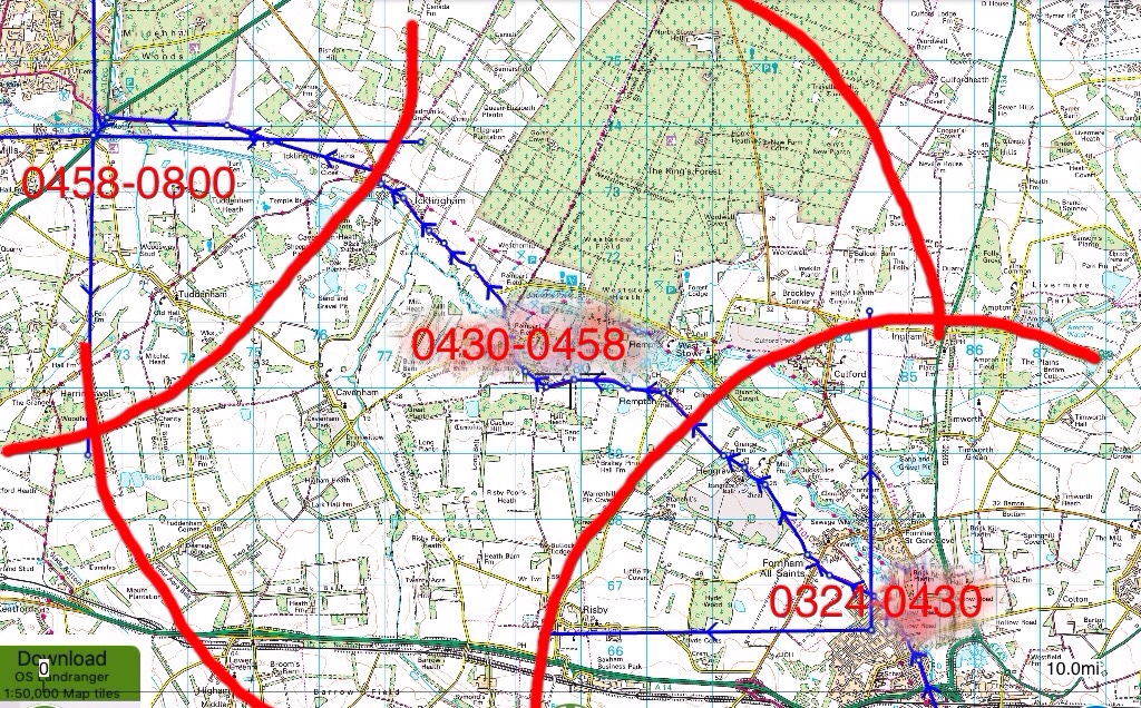
The phone pings 0430 and 0458 give us 28 minutes. Assuming that is roughly the time it took the phone to go thru the dead zone which midsummers map shows as roughly 6 miles this gives us the12 mph. Is that how that speed has been estimated?

Again that's not an easy answer to give. I honestly wish I could even intimate in a positive way so that we could infer from my intimations. As has been stated earlier by James, phone mast TX/RT is not an exact science. Even woods and trees offer up some soot of masking (signal loss).
I'm basing my maps on a rough 3 mile radius of the mast. If you push a road into that mast footprint like the A1101 which we are told the bin lorry took, then even that road has black spots (signal loss). We can however presume that the phone travelled along that route towards BM as its the easiest and most straightforward regardless whether Corrie was with it or not. The phone travelled towards the mast....it's that simple.

Now the complicated part. If you radii from the BM mast an 3-5 mile line and bisect a road that heads towards the mast....that gives you the stated 0458 approximate ping location.
Extrapolate from that a t/s/d equation using a sensible 30mph and the times to all points of the rest of the radii can be worked out (see my map).


Sent from my iPad using Tapatalk
 
Apologies if this has been asked previously, I do follow the threads closely but may have missed it.
Midsummer; Is there a map which shows the masts triangulation? Or are they in a line with only overlaps from two?
I just wondered if the police reference in an early website update is based on triangulation or whether it's either a) withheld evidence based or b) a guess.
https://www.suffolk.police.uk/news/missing-persons/corrie-mckeague
October 2nd update said:
"Enquiries and information received over the past week have led police to believe he may have been in the Mildenhall area at some point between 4.30am and 8am on Saturday 24 September, and police would like to hear from anyone who may have seen or spoken to a man matching Corrie’s description in this area around this time"

The term 'triangulation' is a misnomer. I believe only two masts are used to location the rough approximate location of a device. Intersecting roads with the third mast narrows it down further. Need an expert for that which I ain't. Just got slightly above average knowledge than the layman that's all.


Sent from my iPad using Tapatalk
 
Just trying to verify sources. Top pic doesn't show high wall or hedge and he went from the parking place to So bar so don't know whether his route went near Flex when he left the car.

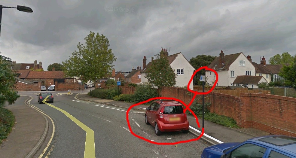
What do you mean by doesn't show high wall? It's right there isn't it?
The hedge is on the opposite side of the road to where the cars are parked. So it's on the left of the image here and the wall is to the right of the pavement. You can see part of the hedge here on this picture and it's quite clear on Streetview.
 
I took the ping times from midsummers map as I thought times were only added if it was from a verified source. Correct me if wrong.

That's the information I've been given. I need to find a link again. If this 'fact' has changed again it will be the third time so far. Look at the smudges under the stated times!


Sent from my iPad using Tapatalk
 
Again that's not an easy answer to give. I honestly wish I could even intimate in a positive way so that we could infer from my intimations. As has been stated earlier by James, phone mast TX/RT is not an exact science. Even woods and trees offer up some soot of masking (signal loss).
I'm basing my maps on a rough 3 mile radius of the mast. If you push a road into that mast footprint like the A1101 which we are told the bin lorry took, then even that road has black spots (signal loss). We can however presume that the phone travelled along that route towards BM as its the easiest and most straightforward regardless whether Corrie was with it or not. The phone travelled towards the mast....it's that simple.

Now the complicated part. If you radii from the BM mast an 3-5 mile line and bisect a road that heads towards the mast....that gives you the stated 0458 approximate ping location.
Extrapolate from that a t/s/d equation using a sensible 30mph and the times to all points of the rest of the radii can be worked out (see my map).


Sent from my iPad using Tapatalk

Also as a side note from this, coverage maps aren't terribly reliable.
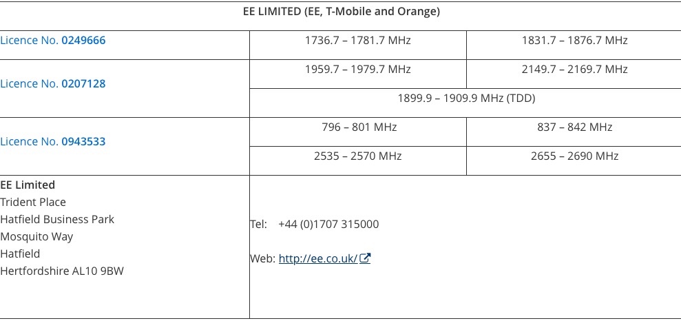
There are EE coverage maps posted here at WS and also on the family website.
I'm not local to BSE but I do have an EE phone and live in a semi-rural area.
The coverage map for my area shows good indoor signal strength for about 1/2 mile radius around, but it's actually a signal black spot. People in my community have relayed this to all of the mobile phone companies as their maps all show good signal for 3G/2G and 'good outdoor' signal for 4G. No action taken by them, maps are inaccurate.
 
Hi guys.

Discussion on Websleuths is based on facts provided by LE, MSM, and in this particular case, the family's updates on findcorrie.co.uk.

We do not allow discussion of rumors or gossip.

Information regarding someone meeting Corrie's friends and his dog, and conversations about a friend getting a lift into Bury with him cannot be verified and are considered rumor.

Also, information regarding where Corrie's American friend is based, or anything else, cannot be "confirmed" by any member here.

Let's stick with the facts that can be linked, please.

Thanks :)
 
The term 'triangulation' is a misnomer. I believe only two masts are used to location the rough approximate location of a device. Intersecting roads with the third mast narrows it down further. Need an expert for that which I ain't. Just got slightly above average knowledge than the layman that's all.


Sent from my iPad using Tapatalk

Yeah, you only need two.
The movies probably need three. But when I was a kid, Starsky and Hutch never got a trace on a call either ! Those pesky crimals kept hanging up !
 
What do you mean by doesn't show high wall? It's right there isn't it?
The hedge is on the opposite side of the road to where the cars are parked. So it's on the left of the image here and the wall is to the right of the pavement. You can see part of the hedge here on this picture and it's quite clear on Streetview.
Ur right I can see a wall but not the hedge. Also I don't know whether this is exactly where he parked or not and I don't know where the cctv is either. Just asking for clarification this is the EXACT spot that's all. Is it exactly where he parked?
 
Ur right I can see a wall but not the hedge. Also I don't know whether this is exactly where he parked or not and I don't know where the cctv is either. Just asking for clarification this is the EXACT spot that's all. Is it exactly where he parked?

It's when Nicola spoke to the students.
He parked in the Disabled Bay. The link is on the other thread.

And that's the only Disabled Bay on the road that Nicola named.
So it's "exactly" the spot.
 
Ur right I can see a wall but not the hedge. Also I don't know whether this is exactly where he parked or not and I don't know where the cctv is either. Just asking for clarification this is the EXACT spot that's all. Is it exactly where he parked?

I dont know where the CCTV is on this one either !
The hedge is over the road, it's visible on streetview and is quite thick and looks quite high. I suppose it could have been trimmed since the streetview cam was down there but bearing in mind it was September, I'll hazard a guess that it was high and thick then too.
 
It's when Nicola spoke to the students.
He parked in the Disabled Bay. The link is on the other thread.

And that's the only Disabled Bay on the road that Nicola named.
So it's "exactly" the spot.
Thanks for confirming that fact James.This leaves just the phone pings to be confirmed or not. This parking spot could end up being the only definate fact we are left with imo.
 
Ur right I can see a wall but not the hedge. Also I don't know whether this is exactly where he parked or not and I don't know where the cctv is either. Just asking for clarification this is the EXACT spot that's all. Is it exactly where he parked?

So to be exact there are two disabled parking spaces. Corrie was parked in one of them. The hedge or bush is opposite the brick wall (see google link below) and goes nearly as high as the lampost! This is because Robert Boby Way is on a hill and the Waitrose car park is about 7-8 feet higher than road level at that point. Waitrose car park may well have CCTV but I doubt it could see Corrie's car.

The nearest CCTV that could catch Corrie walking to So Bar going by the Oct 2015 Streetview is the council camera outside Flex. If a local knows of any others that could change things. I personally feel he wasn't seen on CCTV in the car.

https://www.google.co.uk/maps/@52.2...4!1swnzJQY-4QOmpw8jm8W3nRg!2e0!7i13312!8i6656

I agree.

The Victoria Derbyshire interview confirms he was on the phone to his brother ....and his brother confirms the same in the Sky News coverage. This call was for "some while" (it is estimated about an hour by his brothers comments).

In the Victoria Derbyshire interview, there is some confusion as to who requested the photo from whom....

And later in that interview, it is confirmed that this photo was then sent on to another friend at 0308 by Corrie

This process is confirmed in the FAQ's on the FindCorrie site.

YES, Corrie sent a picture message to a friend, it was part of an earlier conversation.

To avoid any hearsay or rumours and making use of my LLB...

I can only assume that this photo was requested by Corrie during the time that Corrie was parked in the Disabled Bay.

Whilst parked in that Disabled Bay he was drinking and chatting to his brother.

How and when this request took place, I am not privy to.

Nicola stipulates there were other phone calls made by Corrie at that time and at that place.
 
Status
Not open for further replies.

Members online

Online statistics

Members online
83
Guests online
4,052
Total visitors
4,135

Forum statistics

Threads
593,642
Messages
17,990,262
Members
229,193
Latest member
imaguppynotashark
Back
Top