(Robert, if you end up reading this and Barbara was lost in this area and you've changed mind about the abduction scenario, I would urge you to provide more details, a detailed timeline, and photos from your hike with the public. As a volunteer, I would have gone out there again IF I had something else to work with like a photo showing she was there in that environment, or a map of your hike (the mornings and evenings are quite doable for hiking in the desert as the temps drop nicely up there at close to 4000 feet elevation for those of us who are used to the desert. If LE or your lawyer won't let you share information, then share that info with the VI @dbdb11, so they can share it here).
Chiming in to clarify a few more things. The inaccurate description of, "dry lake bed" that someone mentioned is really a dry wash that runs north around the main rock formation that they allegedly walked up to, see attached photo. I walked the wash several times east (downhill) towards the location where the 5th wheel was parked and even double checked the culverts under the road that come out of the wash and then parallel HH dirt road. SAR also extensively walked that wash east and west of Kelbaker rd with the dogs as I observed those last two days before they suspended their search. Also, as I mentioned before, I chatted with the sheriff on site at their incident command 5th wheel, and he confirmed that that was the exact location that Robert allegedly was parked. So that is where they conducted their search operations from.
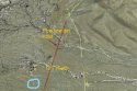
Sweeney Granite Mountains Desert Research Center is not visible from the hike, as there is a ridge that comes from the Granite mountains that blocks that view. If one were to hike to the rock formations, and then skirt around the Granite Mountains towards the research center, it would take about 3.7 miles to get there one way and uphill, so quite a ways from the turnout.
The parking lot many folks have mentioned is just a little ways up the road, near the pass, and is like a scenic view parking area. This is the most plausible parking area for cars making a brief stop. Google Maps You can use the scroll wheel on your mouse to zoom in towards the rock formations and see the pole line. I noted this in my observation from having been there not just driving through, but on my hikes. I was able to see the cars with the naked eye from most of the locations in the attached Google Earth snapshot. So again that 360 degree shot that is mentioned as showing cars would be very helpful to see, so we can see where it was taken from. You'd occasionally see a car or two stopped there for a small break and then they'd be off again.
There have also been many weather numbers thrown around over all these pages. If you want the most accurate temps, the weather station at the UC reserve and research center is the most accurate, as it is a scientifically calibrated weather station. Attached are the daily highs for the day they went hiking. It didn't quite reach the triple digits but still hot. Due to it's elevation, it is not so hot as the surrounding valleys.
Sweeney Granite Mountains California
And also regarding vegetation and "corners", Robert was not clear about this corner, but from walking there, while the trail looks straight on Google Earth, it actually is meandering enough to loose someone out of sight every 100-150 feet or so. And while the cholla vegetation is only 3-4 feet tall, the creosote and other vegetation can be as high as 6 feet or a bit more at times. So she would have gone out of sight pretty fast after "rounding a corner" so to speak. The 5th wheel would have been visible at most times however, due to it being bright and about 12-14 feet tall would be my guess.

")